Dahme geodata
Dahme (Brandenburg) is a populated place; located in Germany in Europe/Berlin (GMT+2) time zone. With population of 5,924 people, there are 2486 cities with bigger population in this country. Compared to other cities in Germany, 70.7% of cities are located further ↓South; 95.3% of cities are located further ←West and 70% of cities have higher elevation than Dahme. Note1
Administrative division(s):
- Level 1: Brandenburg
- Level 3: Landkreis Teltow-Fläming
- Level 4: Dahme/Mark


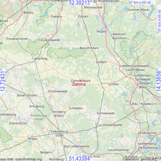
Dahme GPS coordinates[2]
51° 52' 12.288" North, 13° 25' 38.748" East
| Map corner | latitude | longitude |
|---|---|---|
| Upper-left | 52.30213°, | 12.72431° |
| Center: | 51.87008°, | 13.42743° |
| Lower-right: | 51.43384°, | 14.13056° |
| Map W x H: | 96.5×96.5 km | = 60×60mi |
| max Lat: | 55.01917° ⇑29.3% North |
| Dahme: | 51.87008° |
| min Lat: | ⇓70.7% South 47.40724° |
| min Long | Dahme | max Long |
| 5.92978° | 13.42743° | 14.98853° |
| W 95.3%⇐ | ⇒4.7% E |
Elevation
Elevation of Dahme is 91 m = 299 ft, and this is 158.1 m = 519 ft below average elevation for this country.
| Max E: |
1256 m = 4121 ft | 70% |
| Avg. | 249.1 m = 817 ft | |
| Dahme | 91 m = 299 ft | |
Min E: |
-5 m = -16 ft | 30% |
See also: Germany elevation on elevation.city.
Geographical zone
Dahme is located in North temperate zone (between Tropic of Cancer and the Arctic Circle). Distance of this North polar circle is 1633.8 km =1015.2 mi to North.| Distance of | km | miles | from Dahme |
|---|---|---|---|
| North Pole | 4239.6 | 2634.4 | to North |
| Arctic Circle | 1633.8 | 1015.2 | to North |
| Tropic Cancer | 3161.5 | 1964.5 | to South |
| Equator | 5767.4 | 3583.7 | to South |


Nearby cities:
15 places around Dahme: (largest is in red/bold)
• Baruth
20.1 km =12.5 mi,  14°
14°
• Drahnsdorf
11.9 km =7.4 mi,  64°
64°
• Golßen
16.4 km =10.2 mi,  46°
46°
• Herzberg
24.9 km =15.5 mi,  214°
214°
• Hohenbucko
11.8 km =7.3 mi,  166°
166°
• Holzdorf
23 km =14.3 mi,  243°
243°
• Ihlow
6.2 km =3.9 mi,  266°
266°
• Jüterbog
27.6 km =17.1 mi,  300°
300°
• Kasel-Golzig
20 km =12.4 mi,  69°
69°
• Lebusa
8.3 km =5.2 mi,  183°
183°
• Linda
22.3 km =13.9 mi, 266°
• Luckau
19.3 km =12 mi,  95°
95°
• Schlieben
16.5 km =10.3 mi,  190°
190°
• Schönewalde
24.4 km =15.2 mi,  150°
150°
• Sonnewalde
24.9 km =15.5 mi,  142°
142°
Sources, notices
• [Note1] Compared only with cities in Germany existing in our database
• [Src1] Map data: © OpenStreetMap contributors (CC-BY-SA)
• [Src2] Other city data from geonames.org with taken over terms of usage.
• [Src3] Geographical zone / Annual Mean Temperature by Robert A. Rohde @ Wikipedia
