Lebusa geodata
Lebusa (Brandenburg) is a seat of a fourth-order administrative division; located in Germany in Europe/Berlin (GMT+2) time zone. With population of 910 people, there are 7488 cities with bigger population in this country. Compared to other cities in Germany, 69.9% of cities are located further ↓South; 95.3% of cities are located further ←West and 67.6% of cities have higher elevation than Lebusa. Note1


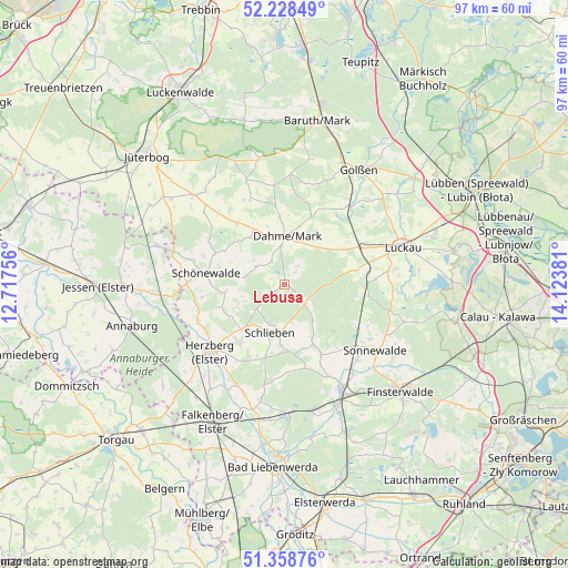
Lebusa GPS coordinates[2]
51° 47' 44.592" North, 13° 25' 14.448" East
| Map corner | latitude | longitude |
|---|---|---|
| Upper-left | 52.22849°, | 12.71756° |
| Center: | 51.79572°, | 13.42068° |
| Lower-right: | 51.35876°, | 14.12381° |
| Map W x H: | 96.7×96.7 km | = 60.1×60.1mi |
| max Lat: | 55.01917° ⇑30.1% North |
| Lebusa: | 51.79572° |
| min Lat: | ⇓69.9% South 47.40724° |
| min Long | Lebusa | max Long |
| 5.92978° | 13.42068° | 14.98853° |
| W 95.3%⇐ | ⇒4.7% E |
Elevation
Elevation of Lebusa is 104 m = 341 ft, and this is 145.1 m = 476 ft below average elevation for this country.
| Max E: |
1256 m = 4121 ft | 67.6% |
| Avg. | 249.1 m = 817 ft | |
| Lebusa | 104 m = 341 ft | |
Min E: |
-5 m = -16 ft | 32.4% |
See also: Germany elevation on elevation.city.
Geographical zone
Lebusa is located in North temperate zone (between Tropic of Cancer and the Arctic Circle). Distance of this North polar circle is 1642 km =1020.3 mi to North.| Distance of | km | miles | from Lebusa |
|---|---|---|---|
| North Pole | 4247.9 | 2639.5 | to North |
| Arctic Circle | 1642 | 1020.3 | to North |
| Tropic Cancer | 3153.2 | 1959.3 | to South |
| Equator | 5759.1 | 3578.5 | to South |


Nearby cities:
15 places around Lebusa: (largest is in red/bold)
• Dahme
8.3 km =5.2 mi,  3°
3°
• Doberlug-Kirchhain
21.3 km =13.2 mi,  152°
152°
• Drahnsdorf
17.5 km =10.9 mi,  39°
39°
• Herzberg
18.4 km =11.4 mi,  228°
228°
• Hohenbucko
4.5 km =2.8 mi,  135°
135°
• Holzdorf
20.2 km =12.6 mi,  264°
264°
• Ihlow
9.8 km =6.1 mi,  324°
324°
• Linda
22.9 km =14.2 mi,  287°
287°
• Luckau
20.7 km =12.9 mi,  72°
72°
• Schilda
21.9 km =13.6 mi,  186°
186°
• Schlieben
8.4 km =5.2 mi,  197°
197°
• Schönborn
22.3 km =13.9 mi,  167°
167°
• Schönewalde
18 km =11.2 mi, 136°
• Sonnewalde
19.4 km =12.1 mi,  126°
126°
• Tröbitz
21.8 km =13.5 mi,  177°
177°
Sources, notices
• [Note1] Compared only with cities in Germany existing in our database
• [Src1] Map data: © OpenStreetMap contributors (CC-BY-SA)
• [Src2] Other city data from geonames.org with taken over terms of usage.
• [Src3] Geographical zone / Annual Mean Temperature by Robert A. Rohde @ Wikipedia
