Hohenhameln geodata
Hohenhameln (Lower Saxony) is a seat of a fourth-order administrative division; located in Germany in Europe/Berlin (GMT+2) time zone. With population of 9,815 people, there are 1653 cities with bigger population in this country. Compared to other cities in Germany, 74.7% of cities are located further ↓South; 51.1% of cities are located further ←West and 67.6% of cities have higher elevation than Hohenhameln. Note1


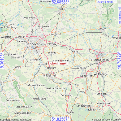
Hohenhameln GPS coordinates[2]
52° 15' 27.18" North, 10° 3' 50.976" East
| Map corner | latitude | longitude |
|---|---|---|
| Upper-left | 52.68586°, | 9.36103° |
| Center: | 52.25755°, | 10.06416° |
| Lower-right: | 51.82507°, | 10.76729° |
| Map W x H: | 95.7×95.7 km | = 59.5×59.5mi |
| max Lat: | 55.01917° ⇑25.3% North |
| Hohenhameln: | 52.25755° |
| min Lat: | ⇓74.7% South 47.40724° |
| min Long | Hohenhameln | max Long |
| 5.92978° | 10.06416° | 14.98853° |
| W 51.1%⇐ | ⇒48.9% E |
Elevation
Elevation of Hohenhameln is 104 m = 341 ft, and this is 145.1 m = 476 ft below average elevation for this country.
| Max E: |
1256 m = 4121 ft | 67.6% |
| Avg. | 249.1 m = 817 ft | |
| Hohenhameln | 104 m = 341 ft | |
Min E: |
-5 m = -16 ft | 32.4% |
See also: Germany elevation on elevation.city.
Geographical zone
Hohenhameln is located in North temperate zone (between Tropic of Cancer and the Arctic Circle). Distance of this North polar circle is 1590.7 km =988.4 mi to North.| Distance of | km | miles | from Hohenhameln |
|---|---|---|---|
| North Pole | 4196.6 | 2607.6 | to North |
| Arctic Circle | 1590.7 | 988.4 | to North |
| Tropic Cancer | 3204.6 | 1991.2 | to South |
| Equator | 5810.5 | 3610.5 | to South |


Nearby cities:
15 places around Hohenhameln: (largest is in red/bold)
• Algermissen
6.5 km =4 mi,  265°
265°
• Arpke
14.5 km =9 mi,  9°
9°
• Burgdorf
16.4 km =10.2 mi,  140°
140°
• Giesen
13.1 km =8.1 mi,  239°
239°
• Harsum
8.6 km =5.3 mi,  232°
232°
• Hildesheim
14.2 km =8.8 mi,  212°
212°
• Ilsede
9.2 km =5.7 mi,  85°
85°
• Lehrte
14 km =8.7 mi,  335°
335°
• Lengede
17.6 km =10.9 mi,  109°
109°
• Peine
13.5 km =8.4 mi,  59°
59°
• Sarstedt
14.5 km =9 mi,  260°
260°
• Schellerten
8.4 km =5.2 mi,  162°
162°
• Schwüblingsen
17.8 km =11.1 mi,  15°
15°
• Sehnde
9.1 km =5.7 mi,  313°
313°
• Söhlde
13.8 km =8.6 mi,  123°
123°
Sources, notices
• [Note1] Compared only with cities in Germany existing in our database
• [Src1] Map data: © OpenStreetMap contributors (CC-BY-SA)
• [Src2] Other city data from geonames.org with taken over terms of usage.
• [Src3] Geographical zone / Annual Mean Temperature by Robert A. Rohde @ Wikipedia
