Sehnde geodata
Sehnde (Lower Saxony) is a seat of a fourth-order administrative division; located in Germany in Europe/Berlin (GMT+2) time zone. With population of 23,060 people, there are 646 cities with bigger population in this country. Compared to other cities in Germany, 75.3% of cities are located further ↓South; 50.5% of cities are located further →East and 74.3% of cities have higher elevation than Sehnde. Note1


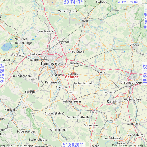
Sehnde GPS coordinates[2]
52° 18' 50.184" North, 9° 58' 5.52" East
| Map corner | latitude | longitude |
|---|---|---|
| Upper-left | 52.7417°, | 9.26508° |
| Center: | 52.31394°, | 9.9682° |
| Lower-right: | 51.88201°, | 10.67133° |
| Map W x H: | 95.6×95.6 km | = 59.4×59.4mi |
| max Lat: | 55.01917° ⇑24.7% North |
| Sehnde: | 52.31394° |
| min Lat: | ⇓75.3% South 47.40724° |
| min Long | Sehnde | max Long |
| 5.92978° | 9.9682° | 14.98853° |
| W 49.5%⇐ | ⇒50.5% E |
Elevation
Elevation of Sehnde is 66 m = 217 ft, and this is 183.1 m = 601 ft below average elevation for this country.
| Max E: |
1256 m = 4121 ft | 74.3% |
| Avg. | 249.1 m = 817 ft | |
| Sehnde | 66 m = 217 ft | |
Min E: |
-5 m = -16 ft | 25.7% |
See also: Germany elevation on elevation.city.
Geographical zone
Sehnde is located in North temperate zone (between Tropic of Cancer and the Arctic Circle). Distance of this North polar circle is 1584.4 km =984.5 mi to North.| Distance of | km | miles | from Sehnde |
|---|---|---|---|
| North Pole | 4190.3 | 2603.7 | to North |
| Arctic Circle | 1584.4 | 984.5 | to North |
| Tropic Cancer | 3210.8 | 1995.1 | to South |
| Equator | 5816.8 | 3614.4 | to South |


Nearby cities:
15 places around Sehnde: (largest is in red/bold)
• Algermissen
6.7 km =4.2 mi,  179°
179°
• Arpke
12 km =7.5 mi,  48°
48°
• Burgdorf
14.9 km =9.3 mi,  9°
9°
• Giesen
13.8 km =8.6 mi,  199°
199°
• Hannover
17.2 km =10.7 mi,  291°
291°
• Harsum
11.5 km =7.1 mi, 181°
• Hemmingen
16.6 km =10.3 mi,  270°
270°
• Hohenhameln
9.1 km =5.7 mi,  133°
133°
• Ilsede
16.7 km =10.4 mi,  109°
109°
• Laatzen
11.6 km =7.2 mi, 270°
• Lehrte
6.5 km =4 mi, 6°
• Pattensen
14.9 km =9.3 mi,  248°
248°
• Sarstedt
11.7 km =7.3 mi,  221°
221°
• Schellerten
17 km =10.6 mi,  147°
147°
• Schwüblingsen
15.8 km =9.8 mi, 46°
Sources, notices
• [Note1] Compared only with cities in Germany existing in our database
• [Src1] Map data: © OpenStreetMap contributors (CC-BY-SA)
• [Src2] Other city data from geonames.org with taken over terms of usage.
• [Src3] Geographical zone / Annual Mean Temperature by Robert A. Rohde @ Wikipedia
