Eichstätt geodata
Eichstätt (Bavaria) is a seat of a third-order administrative division; located in Germany in Europe/Berlin (GMT+2) time zone. With population of 13,125 people, there are 1224 cities with bigger population in this country. Compared to other cities in Germany, 84.2% of cities are located further ↑North; 69.9% of cities are located further ←West and 74.9% of cities have lower elevation than Eichstätt. Note1
Administrative division(s):
- Level 1: Bavaria
- Level 2: Upper Bavaria
- Level 3: Landkreis Eichstätt
- Level 4: Eichstätt


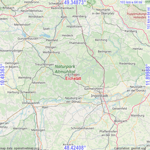
Eichstätt GPS coordinates[2]
48° 53' 18.744" North, 11° 11' 48.3" East
| Map corner | latitude | longitude |
|---|---|---|
| Upper-left | 49.34873°, | 10.49363° |
| Center: | 48.88854°, | 11.19675° |
| Lower-right: | 48.42408°, | 11.89988° |
| Map W x H: | 102.8×102.8 km | = 63.9×63.9mi |
| max Lat: | 55.01917° ⇑84.2% North |
| Eichstätt: | 48.88854° |
| min Lat: | ⇓15.8% South 47.40724° |
| min Long | Eichstätt | max Long |
| 5.92978° | 11.19675° | 14.98853° |
| W 69.9%⇐ | ⇒30.1% E |
Elevation
Elevation of Eichstätt is 397 m = 1302 ft, and this is 147.9 m = 485 ft above average elevation for this country.
| Max E: |
1256 m = 4121 ft | 25.1% |
| Eichstätt | 397 m 1302 ft | |
| Avg. | 249.1 m = 817 ft | |
Min E: |
-5 m = -16 ft | 74.9% |
See also: Germany elevation on elevation.city.
Geographical zone
Eichstätt is located in North temperate zone (between Tropic of Cancer and the Arctic Circle). Distance of this North polar circle is 1965.3 km =1221.2 mi to North.| Distance of | km | miles | from Eichstätt |
|---|---|---|---|
| North Pole | 4571.2 | 2840.4 | to North |
| Arctic Circle | 1965.3 | 1221.2 | to North |
| Tropic Cancer | 2830 | 1758.5 | to South |
| Equator | 5435.9 | 3377.7 | to South |


Nearby cities:
15 places around Eichstätt: (largest is in red/bold)
• Adelschlag
5.6 km =3.5 mi,  163°
163°
• Bergheim
14.9 km =9.3 mi, 162°
• Buxheim
11.5 km =7.1 mi,  142°
142°
• Böhmfeld
12.9 km =8 mi,  103°
103°
• Egweil
12 km =7.5 mi,  167°
167°
• Eitensheim
11.9 km =7.4 mi,  132°
132°
• Gaimersheim
15.5 km =9.6 mi, 125°
• Hitzhofen
9.8 km =6.1 mi,  116°
116°
• Neuburg an der Donau
17.4 km =10.8 mi,  182°
182°
• Pappenheim
17 km =10.6 mi,  287°
287°
• Pollenfeld
6.8 km =4.2 mi,  1°
1°
• Raitenbuch
15 km =9.3 mi,  339°
339°
• Schernfeld
7.2 km =4.5 mi,  280°
280°
• Solnhofen
14.7 km =9.1 mi,  273°
273°
• Walting
8.2 km =5.1 mi,  67°
67°
Sources, notices
• [Note1] Compared only with cities in Germany existing in our database
• [Src1] Map data: © OpenStreetMap contributors (CC-BY-SA)
• [Src2] Other city data from geonames.org with taken over terms of usage.
• [Src3] Geographical zone / Annual Mean Temperature by Robert A. Rohde @ Wikipedia
