Pollenfeld geodata
Pollenfeld (Bavaria) is a seat of a fourth-order administrative division; located in Germany in Europe/Berlin (GMT+2) time zone. In our database, there are 11009 cities with bigger population. Compared to other cities in Germany, 83.5% of cities are located further ↑North; 69.9% of cities are located further ←West and 91.9% of cities have lower elevation than Pollenfeld. Note1
Administrative division(s):
- Level 1: Bavaria
- Level 2: Upper Bavaria
- Level 3: Landkreis Eichstätt
- Level 4: Pollenfeld


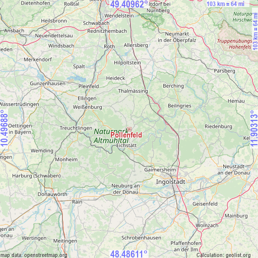
Pollenfeld GPS coordinates[2]
48° 57' 0" North, 11° 12' 0" East
| Map corner | latitude | longitude |
|---|---|---|
| Upper-left | 49.40962°, | 10.49688° |
| Center: | 48.95°, | 11.2° |
| Lower-right: | 48.48611°, | 11.90313° |
| Map W x H: | 102.7×102.7 km | = 63.8×63.8mi |
| max Lat: | 55.01917° ⇑83.5% North |
| Pollenfeld: | 48.95° |
| min Lat: | ⇓16.5% South 47.40724° |
| min Long | Pollenfeld | max Long |
| 5.92978° | 11.2° | 14.98853° |
| W 69.9%⇐ | ⇒30.1% E |
Elevation
Elevation of Pollenfeld is 541 m = 1775 ft, and this is 291.9 m = 958 ft above average elevation for this country.
| Max E: |
1256 m = 4121 ft | 8.1% |
| Pollenfeld | 541 m 1775 ft | |
| Avg. | 249.1 m = 817 ft | |
Min E: |
-5 m = -16 ft | 91.9% |
See also: Germany elevation on elevation.city.
Geographical zone
Pollenfeld is located in North temperate zone (between Tropic of Cancer and the Arctic Circle). Distance of this North polar circle is 1958.4 km =1216.9 mi to North.| Distance of | km | miles | from Pollenfeld |
|---|---|---|---|
| North Pole | 4564.3 | 2836.1 | to North |
| Arctic Circle | 1958.4 | 1216.9 | to North |
| Tropic Cancer | 2836.8 | 1762.7 | to South |
| Equator | 5442.7 | 3381.9 | to South |


Nearby cities:
15 places around Pollenfeld: (largest is in red/bold)
• Adelschlag
12.3 km =7.6 mi,  173°
173°
• Bergen
15.1 km =9.4 mi,  335°
335°
• Burgsalach
11.9 km =7.4 mi,  321°
321°
• Böhmfeld
15.8 km =9.8 mi,  128°
128°
• Eichstätt
6.8 km =4.2 mi,  181°
181°
• Eitensheim
17.1 km =10.6 mi,  150°
150°
• Greding
15.7 km =9.8 mi,  46°
46°
• Hitzhofen
14 km =8.7 mi,  142°
142°
• Nennslingen
11.9 km =7.4 mi,  334°
334°
• Pappenheim
16.6 km =10.3 mi,  263°
263°
• Raitenbuch
9 km =5.6 mi, 322°
• Schernfeld
9.2 km =5.7 mi,  232°
232°
• Solnhofen
16.1 km =10 mi,  248°
248°
• Thalmässing
15.5 km =9.6 mi,  5°
5°
• Walting
8.2 km =5.1 mi,  116°
116°
Sources, notices
• [Note1] Compared only with cities in Germany existing in our database
• [Src1] Map data: © OpenStreetMap contributors (CC-BY-SA)
• [Src2] Other city data from geonames.org with taken over terms of usage.
• [Src3] Geographical zone / Annual Mean Temperature by Robert A. Rohde @ Wikipedia
