Esbjerg geodata
Esbjerg (South Denmark) is a seat of a second-order administrative division; located in Denmark in Europe/Copenhagen (GMT+2) time zone. With population of 72,205 people, there are 5 cities with bigger population in this country. Compared to other cities in Denmark, 69.9% of cities are located further ↑North; 97.4% of cities are located further →East and 56.1% of cities have higher elevation than Esbjerg. Note1


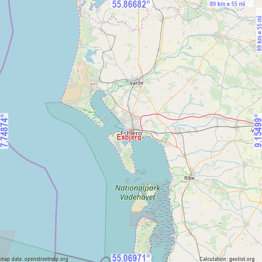
Esbjerg GPS coordinates[2]
55° 28' 13.008" North, 8° 27' 6.732" East
| Map corner | latitude | longitude |
|---|---|---|
| Upper-left | 55.86682°, | 7.74874° |
| Center: | 55.47028°, | 8.45187° |
| Lower-right: | 55.06971°, | 9.15499° |
| Map W x H: | 88.6×88.6 km | = 55.1×55.1mi |
| max Lat: | 57.72093° ⇑69.9% North |
| Esbjerg: | 55.47028° |
| min Lat: | ⇓30.1% South 54.57644° |
| min Long | Esbjerg | max Long |
| 8.12605° | 8.45187° | 15.18662° |
| W 2.6%⇐ | ⇒97.4% E |
Elevation
Elevation of Esbjerg is 17 m = 56 ft, and this is 10.3 m = 34 ft below average elevation for this country.
| Max E: |
114 m = 374 ft | 56.1% |
| Avg. | 27.3 m = 90 ft | |
| Esbjerg | 17 m = 56 ft | |
Min E: |
0 m = 0 ft | 43.9% |
See also: Esbjerg elevation on elevation.city.
Geographical zone
Esbjerg is located in North temperate zone (between Tropic of Cancer and the Arctic Circle). Distance of this North polar circle is 1233.5 km =766.5 mi to North.| Distance of | km | miles | from Esbjerg |
|---|---|---|---|
| North Pole | 3839.3 | 2385.6 | to North |
| Arctic Circle | 1233.5 | 766.5 | to North |
| Tropic Cancer | 3561.8 | 2213.2 | to South |
| Equator | 6167.7 | 3832.4 | to South |


Nearby cities:
15 places around Esbjerg: (largest is in red/bold)
• Bramming
15.6 km =9.7 mi,  90°
90°
• Brørup
35.7 km =22.2 mi, 87°
• Gram
42.8 km =26.6 mi,  118°
118°
• Grindsted
43.7 km =27.2 mi,  43°
43°
• Holsted
29.8 km =18.5 mi,  81°
81°
• Nordby
4.3 km =2.7 mi,  231°
231°
• Oksbøl
20.2 km =12.6 mi,  329°
329°
• Ribe
25.4 km =15.8 mi,  127°
127°
• Rødding
40.3 km =25 mi,  106°
106°
• Skaerbaek
40.2 km =25 mi,  150°
150°
• Tarm
49 km =30.4 mi,  5°
5°
• Tjæreborg
8.1 km =5 mi, 94°
• Varde
16.9 km =10.5 mi, 6°
• Vejen
43.3 km =26.9 mi, 88°
• Ølgod
39 km =24.2 mi,  16°
16°
Sources, notices
• [Note1] Compared only with cities in Denmark existing in our database
• [Src1] Map data: © OpenStreetMap contributors (CC-BY-SA)
• [Src2] Other city data from geonames.org with taken over terms of usage.
• [Src3] Geographical zone / Annual Mean Temperature by Robert A. Rohde @ Wikipedia
