Tjæreborg geodata
Tjæreborg (South Denmark) is a populated place; located in Denmark in Europe/Copenhagen (GMT+2) time zone. With population of 2,146 people, there are 290 cities with bigger population in this country. Compared to other cities in Denmark, 70.8% of cities are located further ↑North; 96.2% of cities are located further →East and 71.9% of cities have higher elevation than Tjæreborg. Note1


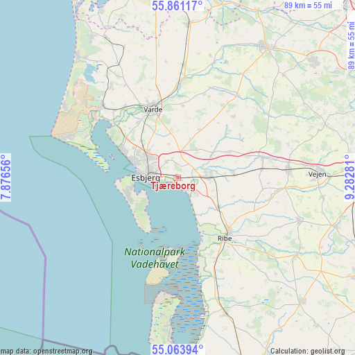
Tjæreborg GPS coordinates[2]
55° 27' 52.452" North, 8° 34' 46.848" East
| Map corner | latitude | longitude |
|---|---|---|
| Upper-left | 55.86117°, | 7.87656° |
| Center: | 55.46457°, | 8.57968° |
| Lower-right: | 55.06394°, | 9.28281° |
| Map W x H: | 88.6×88.6 km | = 55.1×55.1mi |
| max Lat: | 57.72093° ⇑70.8% North |
| Tjæreborg: | 55.46457° |
| min Lat: | ⇓29.2% South 54.57644° |
| min Long | Tjæreborg | max Long |
| 8.12605° | 8.57968° | 15.18662° |
| W 3.8%⇐ | ⇒96.2% E |
Elevation
Elevation of Tjæreborg is 12 m = 39 ft, and this is 15.3 m = 50 ft below average elevation for this country.
| Max E: |
114 m = 374 ft | 71.9% |
| Avg. | 27.3 m = 90 ft | |
| Tjæreborg | 12 m = 39 ft | |
Min E: |
0 m = 0 ft | 28.1% |
See also: Denmark elevation on elevation.city.
Geographical zone
Tjæreborg is located in North temperate zone (between Tropic of Cancer and the Arctic Circle). Distance of this North polar circle is 1234.1 km =766.8 mi to North.| Distance of | km | miles | from Tjæreborg |
|---|---|---|---|
| North Pole | 3840 | 2386.1 | to North |
| Arctic Circle | 1234.1 | 766.8 | to North |
| Tropic Cancer | 3561.2 | 2212.8 | to South |
| Equator | 6167.1 | 3832.1 | to South |


Nearby cities:
15 places around Tjæreborg: (largest is in red/bold)
• Bramming
7.6 km =4.7 mi,  85°
85°
• Brørup
27.7 km =17.2 mi, 85°
• Esbjerg
8.1 km =5 mi,  274°
274°
• Gram
35.5 km =22.1 mi,  123°
123°
• Grindsted
39.2 km =24.4 mi,  33°
33°
• Holsted
22 km =13.7 mi,  76°
76°
• Nordby
11.6 km =7.2 mi,  259°
259°
• Oksbøl
25.7 km =16 mi,  314°
314°
• Ribe
19.1 km =11.9 mi,  141°
141°
• Rødding
32.4 km =20.1 mi,  109°
109°
• Skaerbaek
36.2 km =22.5 mi,  160°
160°
• Toftlund
43.6 km =27.1 mi,  134°
134°
• Varde
18.5 km =11.5 mi,  340°
340°
• Vejen
35.2 km =21.9 mi, 86°
• Ølgod
38.2 km =23.7 mi,  4°
4°
Sources, notices
• [Note1] Compared only with cities in Denmark existing in our database
• [Src1] Map data: © OpenStreetMap contributors (CC-BY-SA)
• [Src2] Other city data from geonames.org with taken over terms of usage.
• [Src3] Geographical zone / Annual Mean Temperature by Robert A. Rohde @ Wikipedia
