Oksbøl geodata
Oksbøl (South Denmark) is a populated place; located in Denmark in Europe/Copenhagen (GMT+2) time zone. With population of 2,845 people, there are 222 cities with bigger population in this country. Compared to other cities in Denmark, 59.1% of cities are located further ↑North; 98.8% of cities are located further →East and 59.6% of cities have higher elevation than Oksbøl. Note1


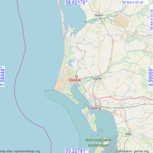
Oksbøl GPS coordinates[2]
55° 37' 36.48" North, 8° 17' 15.252" East
| Map corner | latitude | longitude |
|---|---|---|
| Upper-left | 56.02176°, | 7.58444° |
| Center: | 55.6268°, | 8.28757° |
| Lower-right: | 55.22781°, | 8.99069° |
| Map W x H: | 88.3×88.3 km | = 54.9×54.9mi |
| max Lat: | 57.72093° ⇑59.1% North |
| Oksbøl: | 55.6268° |
| min Lat: | ⇓40.9% South 54.57644° |
| min Long | Oksbøl | max Long |
| 8.12605° | 8.28757° | 15.18662° |
| W 1.2%⇐ | ⇒98.8% E |
Elevation
Elevation of Oksbøl is 16 m = 52 ft, and this is 11.3 m = 37 ft below average elevation for this country.
| Max E: |
114 m = 374 ft | 59.6% |
| Avg. | 27.3 m = 90 ft | |
| Oksbøl | 16 m = 52 ft | |
Min E: |
0 m = 0 ft | 40.4% |
See also: Denmark elevation on elevation.city.
Geographical zone
Oksbøl is located in North temperate zone (between Tropic of Cancer and the Arctic Circle). Distance of this North polar circle is 1216.1 km =755.6 mi to North.| Distance of | km | miles | from Oksbøl |
|---|---|---|---|
| North Pole | 3821.9 | 2374.8 | to North |
| Arctic Circle | 1216.1 | 755.6 | to North |
| Tropic Cancer | 3579.2 | 2224 | to South |
| Equator | 6185.1 | 3843.2 | to South |


Nearby cities:
15 places around Oksbøl: (largest is in red/bold)
• Billund
52.8 km =32.8 mi,  77°
77°
• Bramming
31.3 km =19.4 mi,  123°
123°
• Brørup
48.7 km =30.3 mi,  109°
109°
• Esbjerg
20.2 km =12.6 mi,  149°
149°
• Grindsted
42.6 km =26.5 mi,  70°
70°
• Holsted
41.7 km =25.9 mi, 107°
• Hvide Sande
42.6 km =26.5 mi,  346°
346°
• Nordby
21.3 km =13.2 mi,  160°
160°
• Ribe
44.8 km =27.8 mi,  137°
137°
• Ringkøbing
51.6 km =32.1 mi,  356°
356°
• Skjern
38.3 km =23.8 mi,  20°
20°
• Tarm
34.8 km =21.6 mi,  25°
25°
• Tjæreborg
25.7 km =16 mi,  134°
134°
• Varde
12.1 km =7.5 mi,  92°
92°
• Ølgod
29.3 km =18.2 mi,  46°
46°
Sources, notices
• [Note1] Compared only with cities in Denmark existing in our database
• [Src1] Map data: © OpenStreetMap contributors (CC-BY-SA)
• [Src2] Other city data from geonames.org with taken over terms of usage.
• [Src3] Geographical zone / Annual Mean Temperature by Robert A. Rohde @ Wikipedia
