Jijel geodata
Jijel is a seat of a first-order administrative division; located in Algeria in Africa/Algiers (GMT+1) time zone. With population of 148,000 people, there are 22 cities with bigger population in this country. Compared to other cities in Algeria, 97.3% of cities are located further ↓South; 77.9% of cities are located further ←West and 98.8% of cities have higher elevation than Jijel. Note1


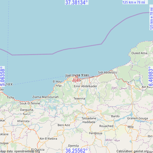
Jijel GPS coordinates[2]
36° 49' 13.98" North, 5° 46' 0.156" East
| Map corner | latitude | longitude |
|---|---|---|
| Upper-left | 37.38134°, | 5.06358° |
| Center: | 36.82055°, | 5.76671° |
| Lower-right: | 36.25562°, | 6.46983° |
| Map W x H: | 125.2×125.2 km | = 77.8×77.8mi |
| max Lat: | 36.92917° ⇑2.7% North |
| Jijel: | 36.82055° |
| min Lat: | ⇓97.3% South 22.785° |
| min Long | Jijel | max Long |
| -8.14743° | 5.76671° | 8.46667° |
| W 77.9%⇐ | ⇒22.1% E |
Elevation
Elevation of Jijel is 9 m = 30 ft, and this is 429.5 m = 1409 ft below average elevation for this country.
| Max E: |
1392 m = 4567 ft | 98.8% |
| Avg. | 438.5 m = 1439 ft | |
| Jijel | 9 m = 30 ft | |
Min E: |
5 m = 16 ft | 1.2% |
See also: Jijel elevation on elevation.city.
Geographical zone
Jijel is located in North temperate zone (between Tropic of Cancer and the Arctic Circle). Distance of this Northern Tropic circle is 1488.1 km =924.7 mi to South.| Distance of | km | miles | from Jijel |
|---|---|---|---|
| North Pole | 5913 | 3674.2 | to North |
| Arctic Circle | 3307.1 | 2054.9 | to North |
| Tropic Cancer | 1488.1 | 924.7 | to South |
| Equator | 4094.1 | 2544 | to South |


Nearby cities:
15 places around Jijel: (largest is in red/bold)
• Amizour
79.7 km =49.5 mi,  255°
255°
• Aïn Arnat
81.3 km =50.5 mi,  209°
209°
• BABOR - VILLE
42 km =26.1 mi, 208°
• Barbacha
76.7 km =47.7 mi,  248°
248°
• Bejaïa
61.2 km =38 mi, 263°
• Bougaa
81.3 km =50.5 mi,  228°
228°
• Chelghoum el Aïd
81.4 km =50.6 mi,  153°
153°
• El Eulma
74.6 km =46.4 mi,  185°
185°
• El Kseur
82.7 km =51.4 mi, 259°
• Karkira
73.8 km =45.9 mi,  80°
80°
• Mila
60.6 km =37.7 mi,  132°
132°
• Rouached
47.3 km =29.4 mi, 148°
• Sidi Mérouane
55.3 km =34.4 mi, 127°
• Sétif
76.8 km =47.7 mi,  204°
204°
• Tamalous
77.8 km =48.3 mi,  88°
88°
Sources, notices
• [Note1] Compared only with cities in Algeria existing in our database
• [Src1] Map data: © OpenStreetMap contributors (CC-BY-SA)
• [Src2] Other city data from geonames.org with taken over terms of usage.
• [Src3] Geographical zone / Annual Mean Temperature by Robert A. Rohde @ Wikipedia
