El Tarf geodata
El Tarf is a seat of a first-order administrative division; located in Algeria in Africa/Algiers (GMT+1) time zone. With population of 20,300 people, there are 227 cities with bigger population in this country. Compared to other cities in Algeria, 93.4% of cities are located further ↓South; 99.2% of cities are located further ←West and 94.2% of cities have higher elevation than El Tarf. Note1


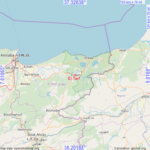
El Tarf GPS coordinates[2]
36° 46' 1.92" North, 8° 18' 49.572" East
| Map corner | latitude | longitude |
|---|---|---|
| Upper-left | 37.32838°, | 7.61065° |
| Center: | 36.7672°, | 8.31377° |
| Lower-right: | 36.20188°, | 9.0169° |
| Map W x H: | 125.3×125.3 km | = 77.9×77.9mi |
| max Lat: | 36.92917° ⇑6.6% North |
| El Tarf: | 36.7672° |
| min Lat: | ⇓93.4% South 22.785° |
| min Long | El Tarf | max Long |
| -8.14743° | 8.31377° | 8.46667° |
| W 99.2%⇐ | ⇒0.8% E |
Elevation
Elevation of El Tarf is 24 m = 79 ft, and this is 414.5 m = 1360 ft below average elevation for this country.
| Max E: |
1392 m = 4567 ft | 94.2% |
| Avg. | 438.5 m = 1439 ft | |
| El Tarf | 24 m = 79 ft | |
Min E: |
5 m = 16 ft | 5.8% |
See also: Algeria elevation on elevation.city.
Geographical zone
El Tarf is located in North temperate zone (between Tropic of Cancer and the Arctic Circle). Distance of this Northern Tropic circle is 1482.2 km =921 mi to South.| Distance of | km | miles | from El Tarf |
|---|---|---|---|
| North Pole | 5918.9 | 3677.8 | to North |
| Arctic Circle | 3313 | 2058.6 | to North |
| Tropic Cancer | 1482.2 | 921 | to South |
| Equator | 4088.1 | 2540.2 | to South |


Nearby cities:
15 places around El Tarf: (largest is in red/bold)
• Annaba
50.9 km =31.6 mi,  286°
286°
• Azzaba
107.7 km =66.9 mi,  268°
268°
• Ben Mehidi
36.3 km =22.6 mi, 270°
• Berrahal
77 km =47.8 mi,  275°
275°
• Besbes
42.2 km =26.2 mi,  260°
260°
• Boumahra Ahmed
79.2 km =49.2 mi,  244°
244°
• Drean
51 km =31.7 mi, 259°
• El Aouinet
107.2 km =66.6 mi,  200°
200°
• El Hadjar
51.5 km =32 mi, 274°
• El Kala
18.3 km =11.4 mi,  38°
38°
• Guelma
86.2 km =53.6 mi,  246°
246°
• Héliopolis
83.1 km =51.6 mi, 249°
• Sedrata
99.5 km =61.8 mi,  224°
224°
• Skikda
125.6 km =78 mi, 275°
• Souk Ahras
62.5 km =38.8 mi,  211°
211°
Sources, notices
• [Note1] Compared only with cities in Algeria existing in our database
• [Src1] Map data: © OpenStreetMap contributors (CC-BY-SA)
• [Src2] Other city data from geonames.org with taken over terms of usage.
• [Src3] Geographical zone / Annual Mean Temperature by Robert A. Rohde @ Wikipedia
