El Aouinet geodata
El Aouinet (Oum el Bouaghi) is a populated place; located in Algeria in Africa/Algiers (GMT+1) time zone. With population of 32,971 people, there are 157 cities with bigger population in this country. Compared to other cities in Algeria, 56.6% of cities are located further ↑North; 96.9% of cities are located further ←West and 68.6% of cities have lower elevation than El Aouinet. Note1


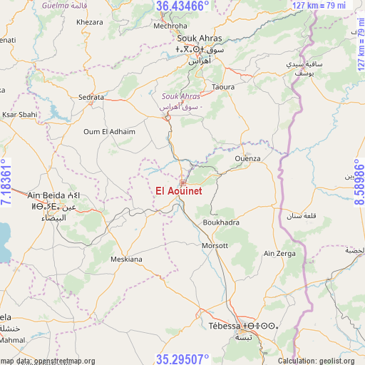
El Aouinet GPS coordinates[2]
35° 52' 0.876" North, 7° 53' 12.228" East
| Map corner | latitude | longitude |
|---|---|---|
| Upper-left | 36.43466°, | 7.18361° |
| Center: | 35.86691°, | 7.88673° |
| Lower-right: | 35.29507°, | 8.58986° |
| Map W x H: | 126.7×126.7 km | = 78.7×78.7mi |
| max Lat: | 36.92917° ⇑56.6% North |
| El Aouinet: | 35.86691° |
| min Lat: | ⇓43.4% South 22.785° |
| min Long | El Aouinet | max Long |
| -8.14743° | 7.88673° | 8.46667° |
| W 96.9%⇐ | ⇒3.1% E |
Elevation
Elevation of El Aouinet is 653 m = 2142 ft, and this is 214.5 m = 704 ft above average elevation for this country.
| Max E: |
1392 m = 4567 ft | 31.4% |
| El Aouinet | 653 m 2142 ft | |
| Avg. | 438.5 m = 1439 ft | |
Min E: |
5 m = 16 ft | 68.6% |
See also: Algeria elevation on elevation.city.
Geographical zone
El Aouinet is located in North temperate zone (between Tropic of Cancer and the Arctic Circle). Distance of this Northern Tropic circle is 1382.1 km =858.8 mi to South.| Distance of | km | miles | from El Aouinet |
|---|---|---|---|
| North Pole | 6019 | 3740 | to North |
| Arctic Circle | 3413.1 | 2120.8 | to North |
| Tropic Cancer | 1382.1 | 858.8 | to South |
| Equator | 3988 | 2478 | to South |


Nearby cities:
15 places around El Aouinet: (largest is in red/bold)
• Aïn Beïda
45.2 km =28.1 mi,  260°
260°
• Aïn Fakroun
91.9 km =57.1 mi,  277°
277°
• Besbes
92.9 km =57.7 mi,  357°
357°
• Boumahra Ahmed
73.8 km =45.9 mi,  333°
333°
• Cheria
67.1 km =41.7 mi,  190°
190°
• Drean
91.8 km =57 mi,  352°
352°
• Guelma
78 km =48.5 mi, 328°
• Hammamet
46.9 km =29.1 mi,  172°
172°
• Héliopolis
81.2 km =50.5 mi, 330°
• Khenchela
82.5 km =51.3 mi,  234°
234°
• Meskiana
33 km =20.5 mi,  217°
217°
• Oum el Bouaghi
69.7 km =43.3 mi,  270°
270°
• Sedrata
43.1 km =26.8 mi,  312°
312°
• Souk Ahras
47 km =29.2 mi,  7°
7°
• Tébessa
55.7 km =34.6 mi,  157°
157°
Sources, notices
• [Note1] Compared only with cities in Algeria existing in our database
• [Src1] Map data: © OpenStreetMap contributors (CC-BY-SA)
• [Src2] Other city data from geonames.org with taken over terms of usage.
• [Src3] Geographical zone / Annual Mean Temperature by Robert A. Rohde @ Wikipedia
