Chelghoum el Aïd geodata
Chelghoum el Aïd (Mila) is a populated place; located in Algeria in Africa/Algiers (GMT+1) time zone. With population of 71,660 people, there are 57 cities with bigger population in this country. Compared to other cities in Algeria, 54.3% of cities are located further ↓South; 82.2% of cities are located further ←West and 74% of cities have lower elevation than Chelghoum el Aïd. Note1


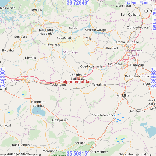
Chelghoum el Aïd GPS coordinates[2]
36° 9' 46.296" North, 6° 9' 59.436" East
| Map corner | latitude | longitude |
|---|---|---|
| Upper-left | 36.72846°, | 5.46338° |
| Center: | 36.16286°, | 6.16651° |
| Lower-right: | 35.59315°, | 6.86963° |
| Map W x H: | 126.2×126.2 km | = 78.4×78.4mi |
| max Lat: | 36.92917° ⇑45.7% North |
| Chelghoum el Aïd: | 36.16286° |
| min Lat: | ⇓54.3% South 22.785° |
| min Long | Chelghoum el A� | max Long |
| -8.14743° | 6.16651° | 8.46667° |
| W 82.2%⇐ | ⇒17.8% E |
Elevation
Elevation of Chelghoum el Aïd is 766 m = 2513 ft, and this is 327.5 m = 1074 ft above average elevation for this country.
| Max E: |
1392 m = 4567 ft | 26% |
| Chelghoum el Aïd | 766 m 2513 ft | |
| Avg. | 438.5 m = 1439 ft | |
Min E: |
5 m = 16 ft | 74% |
See also: Chelghoum el Aïd elevation on elevation.city.
Geographical zone
Chelghoum el Aïd is located in North temperate zone (between Tropic of Cancer and the Arctic Circle). Distance of this Northern Tropic circle is 1415 km =879.2 mi to South.| Distance of | km | miles | from Chelghoum el Aïd |
|---|---|---|---|
| North Pole | 5986.1 | 3719.6 | to North |
| Arctic Circle | 3380.2 | 2100.4 | to North |
| Tropic Cancer | 1415 | 879.2 | to South |
| Equator | 4020.9 | 2498.5 | to South |


Nearby cities:
15 places around Chelghoum el Aïd: (largest is in red/bold)
• Aïn Fakroun
67 km =41.6 mi,  108°
108°
• Aïn Kercha
54.4 km =33.8 mi,  119°
119°
• Aïn Smara
32.2 km =20 mi,  68°
68°
• BABOR - VILLE
66.9 km =41.6 mi,  302°
302°
• Batna
67.5 km =41.9 mi,  179°
179°
• Constantine
46 km =28.6 mi,  60°
60°
• Didouche Mourad
53 km =32.9 mi,  52°
52°
• El Eulma
42.8 km =26.6 mi,  268°
268°
• El Khroub
48.6 km =30.2 mi,  76°
76°
• Hamma Bouziane
47.4 km =29.5 mi, 54°
• Merouana
63.4 km =39.4 mi,  201°
201°
• Mila
33.1 km =20.6 mi,  15°
15°
• Rouached
34.6 km =21.5 mi,  341°
341°
• Sidi Mérouane
40.7 km =25.3 mi,  12°
12°
• Telerghma
17.6 km =10.9 mi, 106°
Sources, notices
• [Note1] Compared only with cities in Algeria existing in our database
• [Src1] Map data: © OpenStreetMap contributors (CC-BY-SA)
• [Src2] Other city data from geonames.org with taken over terms of usage.
• [Src3] Geographical zone / Annual Mean Temperature by Robert A. Rohde @ Wikipedia
