Bordj Zemoura geodata
Bordj Zemoura (Bordj Bou Arréridj) is a populated place; located in Algeria in Africa/Algiers (GMT+1) time zone. With population of 19,782 people, there are 232 cities with bigger population in this country. Compared to other cities in Algeria, 59.7% of cities are located further ↓South; 69% of cities are located further ←West and 91.9% of cities have lower elevation than Bordj Zemoura. Note1


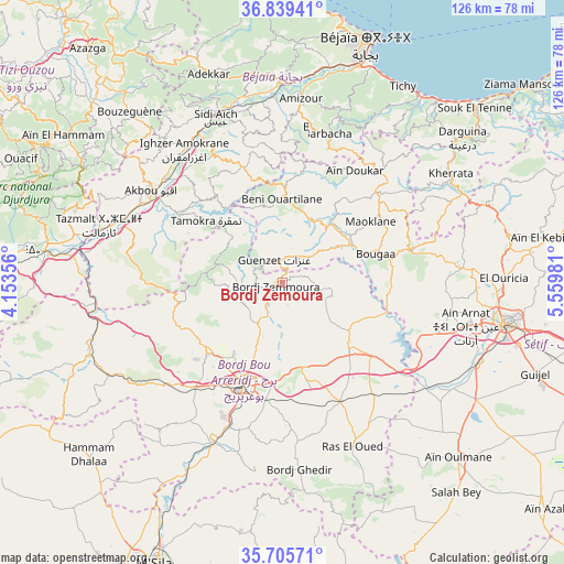
Bordj Zemoura GPS coordinates[2]
36° 16' 28.632" North, 4° 51' 24.048" East
| Map corner | latitude | longitude |
|---|---|---|
| Upper-left | 36.83941°, | 4.15356° |
| Center: | 36.27462°, | 4.85668° |
| Lower-right: | 35.70571°, | 5.55981° |
| Map W x H: | 126.1×126.1 km | = 78.4×78.4mi |
| max Lat: | 36.92917° ⇑40.3% North |
| Bordj Zemoura: | 36.27462° |
| min Lat: | ⇓59.7% South 22.785° |
| min Long | Bordj Zemoura | max Long |
| -8.14743° | 4.85668° | 8.46667° |
| W 69%⇐ | ⇒31% E |
Elevation
Elevation of Bordj Zemoura is 1043 m = 3422 ft, and this is 604.5 m = 1983 ft above average elevation for this country.
| Max E: |
1392 m = 4567 ft | 8.1% |
| Bordj Zemoura | 1043 m 3422 ft | |
| Avg. | 438.5 m = 1439 ft | |
Min E: |
5 m = 16 ft | 91.9% |
See also: Algeria elevation on elevation.city.
Geographical zone
Bordj Zemoura is located in North temperate zone (between Tropic of Cancer and the Arctic Circle). Distance of this Northern Tropic circle is 1427.4 km =886.9 mi to South.| Distance of | km | miles | from Bordj Zemoura |
|---|---|---|---|
| North Pole | 5973.7 | 3711.9 | to North |
| Arctic Circle | 3367.8 | 2092.7 | to North |
| Tropic Cancer | 1427.4 | 886.9 | to South |
| Equator | 4033.4 | 2506.2 | to South |


Nearby cities:
15 places around Bordj Zemoura: (largest is in red/bold)
• Akbou
35.3 km =21.9 mi,  305°
305°
• Amizour
40.8 km =25.4 mi,  5°
5°
• Aïn Arnat
42.1 km =26.2 mi,  103°
103°
• Barbacha
33.9 km =21.1 mi,  16°
16°
• Bordj Bou Arreridj
24 km =14.9 mi,  200°
200°
• Bordj Ghdir
41.7 km =25.9 mi,  174°
174°
• Bougaa
21.8 km =13.5 mi,  72°
72°
• Chemini
42.1 km =26.2 mi,  329°
329°
• El Achir
31.2 km =19.4 mi,  221°
221°
• Feraoun
31.8 km =19.8 mi,  359°
359°
• Ighram
37.8 km =23.5 mi,  303°
303°
• Mansourah
41.9 km =26 mi,  240°
240°
• Râs el Oued
39.9 km =24.8 mi,  156°
156°
• Seddouk
33.9 km =21.1 mi, 333°
• el hed
42.4 km =26.3 mi,  349°
349°
Sources, notices
• [Note1] Compared only with cities in Algeria existing in our database
• [Src1] Map data: © OpenStreetMap contributors (CC-BY-SA)
• [Src2] Other city data from geonames.org with taken over terms of usage.
• [Src3] Geographical zone / Annual Mean Temperature by Robert A. Rohde @ Wikipedia
