Bordj Ghdir geodata
Bordj Ghdir (Bordj Bou Arréridj) is a populated place; located in Algeria in Africa/Algiers (GMT+1) time zone. With population of 34,136 people, there are 151 cities with bigger population in this country. Compared to other cities in Algeria, 53.9% of cities are located further ↑North; 69.4% of cities are located further ←West and 93.8% of cities have lower elevation than Bordj Ghdir. Note1


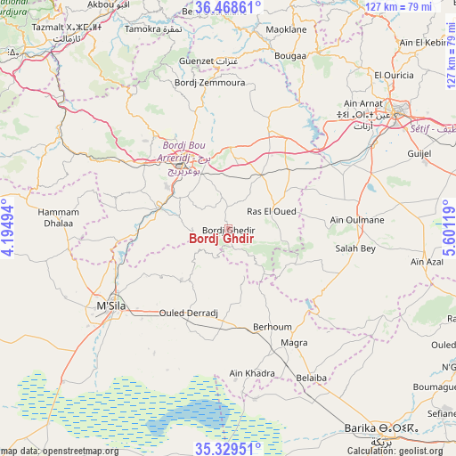
Bordj Ghdir GPS coordinates[2]
35° 54' 3.996" North, 4° 53' 53.016" East
| Map corner | latitude | longitude |
|---|---|---|
| Upper-left | 36.46861°, | 4.19494° |
| Center: | 35.90111°, | 4.89806° |
| Lower-right: | 35.32951°, | 5.60119° |
| Map W x H: | 126.7×126.7 km | = 78.7×78.7mi |
| max Lat: | 36.92917° ⇑53.9% North |
| Bordj Ghdir: | 35.90111° |
| min Lat: | ⇓46.1% South 22.785° |
| min Long | Bordj Ghdir | max Long |
| -8.14743° | 4.89806° | 8.46667° |
| W 69.4%⇐ | ⇒30.6% E |
Elevation
Elevation of Bordj Ghdir is 1088 m = 3570 ft, and this is 649.5 m = 2131 ft above average elevation for this country.
| Max E: |
1392 m = 4567 ft | 6.2% |
| Bordj Ghdir | 1088 m 3570 ft | |
| Avg. | 438.5 m = 1439 ft | |
Min E: |
5 m = 16 ft | 93.8% |
See also: Algeria elevation on elevation.city.
Geographical zone
Bordj Ghdir is located in North temperate zone (between Tropic of Cancer and the Arctic Circle). Distance of this Northern Tropic circle is 1385.9 km =861.2 mi to South.| Distance of | km | miles | from Bordj Ghdir |
|---|---|---|---|
| North Pole | 6015.2 | 3737.7 | to North |
| Arctic Circle | 3409.3 | 2118.4 | to North |
| Tropic Cancer | 1385.9 | 861.2 | to South |
| Equator | 3991.8 | 2480.4 | to South |


Nearby cities:
15 places around Bordj Ghdir: (largest is in red/bold)
• Akbou
69.9 km =43.4 mi,  332°
332°
• Aïn Arnat
49 km =30.4 mi,  49°
49°
• Barika
70.9 km =44.1 mi,  143°
143°
• Bordj Bou Arreridj
22.8 km =14.2 mi, 327°
• Bordj Zemoura
41.7 km =25.9 mi,  354°
354°
• Bougaa
51 km =31.7 mi,  19°
19°
• El Achir
30.3 km =18.8 mi,  306°
306°
• Ighram
71.7 km =44.6 mi, 330°
• Mansourah
45.2 km =28.1 mi,  297°
297°
• Melouza
64.6 km =40.1 mi,  277°
277°
• M’Sila
38.8 km =24.1 mi,  235°
235°
• Râs el Aïoun
72 km =44.7 mi,  110°
110°
• Râs el Oued
12.9 km =8 mi,  68°
68°
• Salah Bey
35.7 km =22.2 mi,  98°
98°
• Sétif
56.5 km =35.1 mi,  55°
55°
Sources, notices
• [Note1] Compared only with cities in Algeria existing in our database
• [Src1] Map data: © OpenStreetMap contributors (CC-BY-SA)
• [Src2] Other city data from geonames.org with taken over terms of usage.
• [Src3] Geographical zone / Annual Mean Temperature by Robert A. Rohde @ Wikipedia
