Mansourah geodata
Mansourah (Bordj Bou Arréridj) is a populated place; located in Algeria in Africa/Algiers (GMT+1) time zone. With population of 22,117 people, there are 216 cities with bigger population in this country. Compared to other cities in Algeria, 50.8% of cities are located further ↓South; 64.7% of cities are located further ←West and 69.8% of cities have lower elevation than Mansourah. Note1


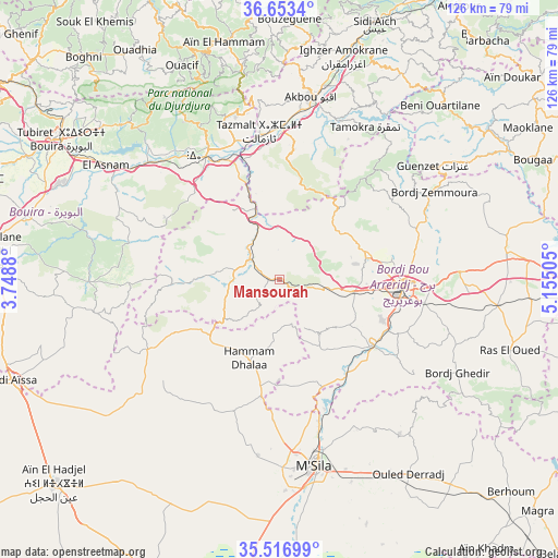
Mansourah GPS coordinates[2]
36° 5' 14.1" North, 4° 27' 6.912" East
| Map corner | latitude | longitude |
|---|---|---|
| Upper-left | 36.6534°, | 3.7488° |
| Center: | 36.08725°, | 4.45192° |
| Lower-right: | 35.51699°, | 5.15505° |
| Map W x H: | 126.4×126.4 km | = 78.5×78.5mi |
| max Lat: | 36.92917° ⇑49.2% North |
| Mansourah: | 36.08725° |
| min Lat: | ⇓50.8% South 22.785° |
| min Long | Mansourah | max Long |
| -8.14743° | 4.45192° | 8.46667° |
| W 64.7%⇐ | ⇒35.3% E |
Elevation
Elevation of Mansourah is 667 m = 2188 ft, and this is 228.5 m = 750 ft above average elevation for this country.
| Max E: |
1392 m = 4567 ft | 30.2% |
| Mansourah | 667 m 2188 ft | |
| Avg. | 438.5 m = 1439 ft | |
Min E: |
5 m = 16 ft | 69.8% |
See also: Algeria elevation on elevation.city.
Geographical zone
Mansourah is located in North temperate zone (between Tropic of Cancer and the Arctic Circle). Distance of this Northern Tropic circle is 1406.6 km =874 mi to South.| Distance of | km | miles | from Mansourah |
|---|---|---|---|
| North Pole | 5994.5 | 3724.8 | to North |
| Arctic Circle | 3388.6 | 2105.6 | to North |
| Tropic Cancer | 1406.6 | 874 | to South |
| Equator | 4012.5 | 2493.3 | to South |


Nearby cities:
15 places around Mansourah: (largest is in red/bold)
• Ait Yahia
56.8 km =35.3 mi,  349°
349°
• Akbou
41.8 km =26 mi,  10°
10°
• Bordj Bou Arreridj
27.8 km =17.3 mi,  93°
93°
• Bordj Ghdir
45.2 km =28.1 mi,  117°
117°
• Bordj Zemoura
41.9 km =26 mi,  60°
60°
• Bouïra
58.8 km =36.5 mi,  302°
302°
• Chemini
58.9 km =36.6 mi, 14°
• Chorfa
32.9 km =20.4 mi,  339°
339°
• El Achir
16 km =9.9 mi,  99°
99°
• Ighram
42 km =26.1 mi, 6°
• Melouza
26.7 km =16.6 mi,  243°
243°
• M’Sila
43.2 km =26.8 mi,  169°
169°
• Râs el Oued
54.5 km =33.9 mi,  106°
106°
• Seddouk
55.3 km =34.4 mi,  22°
22°
• ’Aïn el Hammam
54.7 km =34 mi, 346°
Sources, notices
• [Note1] Compared only with cities in Algeria existing in our database
• [Src1] Map data: © OpenStreetMap contributors (CC-BY-SA)
• [Src2] Other city data from geonames.org with taken over terms of usage.
• [Src3] Geographical zone / Annual Mean Temperature by Robert A. Rohde @ Wikipedia
