Bordj Bou Arreridj geodata
Bordj Bou Arreridj (Bordj Bou Arréridj) is a seat of a first-order administrative division; located in Algeria in Africa/Algiers (GMT+1) time zone. With population of 168,346 people, there are 14 cities with bigger population in this country. Compared to other cities in Algeria, 50.4% of cities are located further ↓South; 67.4% of cities are located further ←West and 83.3% of cities have lower elevation than Bordj Bou Arreridj. Note1


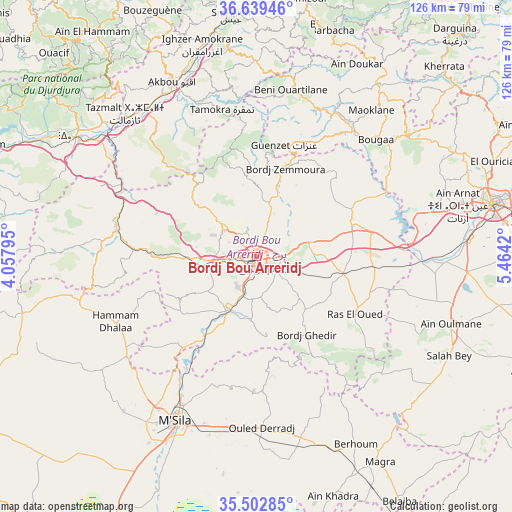
Bordj Bou Arreridj GPS coordinates[2]
36° 4' 23.556" North, 4° 45' 39.888" East
| Map corner | latitude | longitude |
|---|---|---|
| Upper-left | 36.63946°, | 4.05795° |
| Center: | 36.07321°, | 4.76108° |
| Lower-right: | 35.50285°, | 5.4642° |
| Map W x H: | 126.4×126.4 km | = 78.5×78.5mi |
| max Lat: | 36.92917° ⇑49.6% North |
| Bordj Bou Arreridj: | 36.07321° |
| min Lat: | ⇓50.4% South 22.785° |
| min Long | Bordj Bou Arrer | max Long |
| -8.14743° | 4.76108° | 8.46667° |
| W 67.4%⇐ | ⇒32.6% E |
Elevation
Elevation of Bordj Bou Arreridj is 906 m = 2972 ft, and this is 467.5 m = 1534 ft above average elevation for this country.
| Max E: |
1392 m = 4567 ft | 16.7% |
| Bordj Bou Arreridj | 906 m 2972 ft | |
| Avg. | 438.5 m = 1439 ft | |
Min E: |
5 m = 16 ft | 83.3% |
See also: Bordj Bou Arreridj elevation on elevation.city.
Geographical zone
Bordj Bou Arreridj is located in North temperate zone (between Tropic of Cancer and the Arctic Circle). Distance of this Northern Tropic circle is 1405 km =873 mi to South.| Distance of | km | miles | from Bordj Bou Arreridj |
|---|---|---|---|
| North Pole | 5996.1 | 3725.8 | to North |
| Arctic Circle | 3390.2 | 2106.6 | to North |
| Tropic Cancer | 1405 | 873 | to South |
| Equator | 4011 | 2492.3 | to South |


Nearby cities:
15 places around Bordj Bou Arreridj: (largest is in red/bold)
• Akbou
47.3 km =29.4 mi,  334°
334°
• Aïn Arnat
51.2 km =31.8 mi,  75°
75°
• Bordj Ghdir
22.8 km =14.2 mi,  147°
147°
• Bordj Zemoura
24 km =14.9 mi,  20°
20°
• Bougaa
41.2 km =25.6 mi,  45°
45°
• Chorfa
50.7 km =31.5 mi,  309°
309°
• El Achir
12.1 km =7.5 mi,  265°
265°
• Feraoun
54.8 km =34.1 mi,  8°
8°
• Ighram
49 km =30.4 mi, 332°
• Mansourah
27.8 km =17.3 mi, 273°
• Melouza
52.7 km =32.7 mi,  258°
258°
• M’Sila
45.4 km =28.2 mi,  205°
205°
• Râs el Oued
28.2 km =17.5 mi,  120°
120°
• Salah Bey
53.5 km =33.2 mi, 117°
• Seddouk
53.1 km =33 mi,  352°
352°
Sources, notices
• [Note1] Compared only with cities in Algeria existing in our database
• [Src1] Map data: © OpenStreetMap contributors (CC-BY-SA)
• [Src2] Other city data from geonames.org with taken over terms of usage.
• [Src3] Geographical zone / Annual Mean Temperature by Robert A. Rohde @ Wikipedia
