Bougaa geodata
Bougaa (Sétif) is a populated place; located in Algeria in Africa/Algiers (GMT+1) time zone. With population of 38,597 people, there are 135 cities with bigger population in this country. Compared to other cities in Algeria, 60.9% of cities are located further ↓South; 71.7% of cities are located further ←West and 79.1% of cities have lower elevation than Bougaa. Note1


Bougaa GPS coordinates[2]
36° 19' 58.548" North, 5° 5' 18.348" East
| Map corner | latitude | longitude |
|---|---|---|
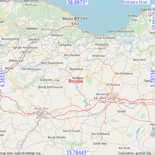
| Upper-left | 36.8973°, | 4.38531° |
| Center: | 36.33293°, | 5.08843° |
| Lower-right: | 35.76445°, | 5.79156° |
| Map W x H: | 126×126 km | = 78.3×78.3mi |
| max Lat: | 36.92917° ⇑39.1% North |
| Bougaa: | 36.33293° |
| min Lat: | ⇓60.9% South 22.785° |
| min Long | Bougaa | max Long |
| -8.14743° | 5.08843° | 8.46667° |
| W 71.7%⇐ | ⇒28.3% E |
Elevation
Elevation of Bougaa is 859 m = 2818 ft, and this is 420.5 m = 1380 ft above average elevation for this country.
| Max E: |
1392 m = 4567 ft | 20.9% |
| Bougaa | 859 m 2818 ft | |
| Avg. | 438.5 m = 1439 ft | |
Min E: |
5 m = 16 ft | 79.1% |
See also: Algeria elevation on elevation.city.
Geographical zone
Bougaa is located in North temperate zone (between Tropic of Cancer and the Arctic Circle). Distance of this Northern Tropic circle is 1433.9 km =891 mi to South.| Distance of | km | miles | from Bougaa |
|---|---|---|---|
| North Pole | 5967.2 | 3707.8 | to North |
| Arctic Circle | 3361.3 | 2088.6 | to North |
| Tropic Cancer | 1433.9 | 891 | to South |
| Equator | 4039.8 | 2510.2 | to South |


Nearby cities:
15 places around Bougaa: (largest is in red/bold)
• Amizour
38 km =23.6 mi,  333°
333°
• Aïn Arnat
25.9 km =16.1 mi,  128°
128°
• BABOR - VILLE
44 km =27.3 mi,  66°
66°
• Barbacha
28.2 km =17.5 mi,  337°
337°
• Bejaïa
47 km =29.2 mi,  359°
359°
• Bordj Bou Arreridj
41.2 km =25.6 mi,  225°
225°
• Bordj Ghdir
51 km =31.7 mi,  199°
199°
• Bordj Zemoura
21.8 km =13.5 mi,  252°
252°
• El Achir
51 km =31.7 mi, 234°
• El Kseur
43.8 km =27.2 mi, 331°
• Feraoun
32.8 km =20.4 mi,  320°
320°
• Râs el Oued
43.5 km =27 mi,  186°
186°
• Seddouk
43.2 km =26.8 mi,  303°
303°
• Sétif
33.2 km =20.6 mi,  118°
118°
• el hed
45.1 km =28 mi, 321°
Sources, notices
• [Note1] Compared only with cities in Algeria existing in our database
• [Src1] Map data: © OpenStreetMap contributors (CC-BY-SA)
• [Src2] Other city data from geonames.org with taken over terms of usage.
• [Src3] Geographical zone / Annual Mean Temperature by Robert A. Rohde @ Wikipedia
