Amizour geodata
Amizour (Béjaïa) is a populated place; located in Algeria in Africa/Algiers (GMT+1) time zone. With population of 25,825 people, there are 198 cities with bigger population in this country. Compared to other cities in Algeria, 80.2% of cities are located further ↓South; 69.8% of cities are located further ←West and 75.6% of cities have higher elevation than Amizour. Note1


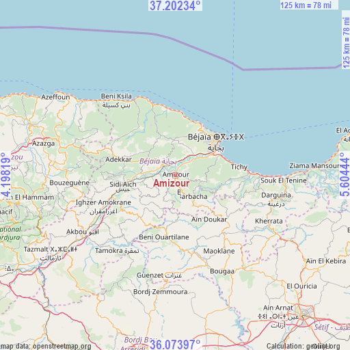
Amizour GPS coordinates[2]
36° 38' 24.792" North, 4° 54' 4.716" East
| Map corner | latitude | longitude |
|---|---|---|
| Upper-left | 37.20234°, | 4.19819° |
| Center: | 36.64022°, | 4.90131° |
| Lower-right: | 36.07397°, | 5.60444° |
| Map W x H: | 125.5×125.5 km | = 78×78mi |
| max Lat: | 36.92917° ⇑19.8% North |
| Amizour: | 36.64022° |
| min Lat: | ⇓80.2% South 22.785° |
| min Long | Amizour | max Long |
| -8.14743° | 4.90131° | 8.46667° |
| W 69.8%⇐ | ⇒30.2% E |
Elevation
Elevation of Amizour is 96 m = 315 ft, and this is 342.5 m = 1124 ft below average elevation for this country.
| Max E: |
1392 m = 4567 ft | 75.6% |
| Avg. | 438.5 m = 1439 ft | |
| Amizour | 96 m = 315 ft | |
Min E: |
5 m = 16 ft | 24.4% |
See also: Algeria elevation on elevation.city.
Geographical zone
Amizour is located in North temperate zone (between Tropic of Cancer and the Arctic Circle). Distance of this Northern Tropic circle is 1468.1 km =912.2 mi to South.| Distance of | km | miles | from Amizour |
|---|---|---|---|
| North Pole | 5933.1 | 3686.7 | to North |
| Arctic Circle | 3327.2 | 2067.4 | to North |
| Tropic Cancer | 1468.1 | 912.2 | to South |
| Equator | 4074 | 2531.5 | to South |


Nearby cities:
15 places around Amizour: (largest is in red/bold)
• Ait Yahia
50.9 km =31.6 mi,  263°
263°
• Akbou
38.5 km =23.9 mi,  238°
238°
• Azazga
48.6 km =30.2 mi,  283°
283°
• Barbacha
10 km =6.2 mi,  144°
144°
• Bejaïa
20.8 km =12.9 mi,  51°
51°
• Bordj Zemoura
40.8 km =25.4 mi,  185°
185°
• Bougaa
38 km =23.6 mi,  153°
153°
• Chemini
25.8 km =16 mi, 260°
• El Kseur
6 km =3.7 mi,  316°
316°
• Feraoun
9.8 km =6.1 mi,  205°
205°
• Freha
53.7 km =33.4 mi, 283°
• Ighram
40.5 km =25.2 mi, 240°
• Seddouk
21.8 km =13.5 mi, 241°
• el hed
11.4 km =7.1 mi, 275°
• ’Aïn el Hammam
53.8 km =33.4 mi, 261°
Sources, notices
• [Note1] Compared only with cities in Algeria existing in our database
• [Src1] Map data: © OpenStreetMap contributors (CC-BY-SA)
• [Src2] Other city data from geonames.org with taken over terms of usage.
• [Src3] Geographical zone / Annual Mean Temperature by Robert A. Rohde @ Wikipedia
