El Kseur geodata
El Kseur (Béjaïa) is a populated place; located in Algeria in Africa/Algiers (GMT+1) time zone. With population of 26,050 people, there are 197 cities with bigger population in this country. Compared to other cities in Algeria, 83.7% of cities are located further ↓South; 68.6% of cities are located further ←West and 80.6% of cities have higher elevation than El Kseur. Note1


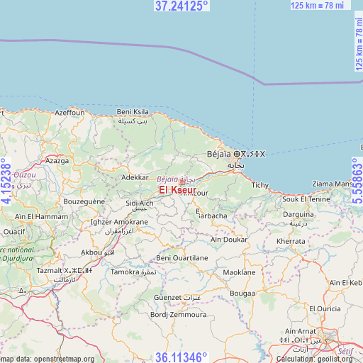
El Kseur GPS coordinates[2]
36° 40' 45.912" North, 4° 51' 19.8" East
| Map corner | latitude | longitude |
|---|---|---|
| Upper-left | 37.24125°, | 4.15238° |
| Center: | 36.67942°, | 4.8555° |
| Lower-right: | 36.11346°, | 5.55863° |
| Map W x H: | 125.4×125.4 km | = 77.9×77.9mi |
| max Lat: | 36.92917° ⇑16.3% North |
| El Kseur: | 36.67942° |
| min Lat: | ⇓83.7% South 22.785° |
| min Long | El Kseur | max Long |
| -8.14743° | 4.8555° | 8.46667° |
| W 68.6%⇐ | ⇒31.4% E |
Elevation
Elevation of El Kseur is 84 m = 276 ft, and this is 354.5 m = 1163 ft below average elevation for this country.
| Max E: |
1392 m = 4567 ft | 80.6% |
| Avg. | 438.5 m = 1439 ft | |
| El Kseur | 84 m = 276 ft | |
Min E: |
5 m = 16 ft | 19.4% |
See also: Algeria elevation on elevation.city.
Geographical zone
El Kseur is located in North temperate zone (between Tropic of Cancer and the Arctic Circle). Distance of this Northern Tropic circle is 1472.5 km =915 mi to South.| Distance of | km | miles | from El Kseur |
|---|---|---|---|
| North Pole | 5928.7 | 3683.9 | to North |
| Arctic Circle | 3322.8 | 2064.7 | to North |
| Tropic Cancer | 1472.5 | 915 | to South |
| Equator | 4078.4 | 2534.2 | to South |


Nearby cities:
15 places around El Kseur: (largest is in red/bold)
• Ait Yahia
47.5 km =29.5 mi,  257°
257°
• Akbou
37.8 km =23.5 mi,  229°
229°
• Amizour
6 km =3.7 mi,  136°
136°
• Arhribs
50.1 km =31.1 mi,  284°
284°
• Azazga
43.7 km =27.2 mi, 279°
• Barbacha
16 km =9.9 mi, 141°
• Bejaïa
22.1 km =13.7 mi,  67°
67°
• Bordj Zemoura
45 km =28 mi,  179°
179°
• Bougaa
43.8 km =27.2 mi,  151°
151°
• Chemini
23.1 km =14.4 mi,  247°
247°
• Feraoun
13.2 km =8.2 mi, 180°
• Freha
48.8 km =30.3 mi, 279°
• Ighram
39.5 km =24.5 mi, 232°
• Seddouk
21.1 km =13.1 mi, 225°
• el hed
8 km =5 mi, 245°
Sources, notices
• [Note1] Compared only with cities in Algeria existing in our database
• [Src1] Map data: © OpenStreetMap contributors (CC-BY-SA)
• [Src2] Other city data from geonames.org with taken over terms of usage.
• [Src3] Geographical zone / Annual Mean Temperature by Robert A. Rohde @ Wikipedia
