Santa Clara geodata
Santa Clara (Pastaza) is a seat of a second-order administrative division; located in Ecuador in America/Guayaquil (GMT-5) time zone. In our database, there are 114 cities with bigger population. Compared to other cities in Ecuador, 57% of cities are located further ↓South; 91.7% of cities are located further ←West and 59.5% of cities have lower elevation than Santa Clara. Note1


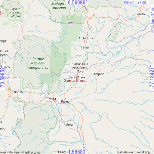
Santa Clara GPS coordinates[2]
1° 15' 50.364" South, 77° 53' 14.604" West
| Map corner | latitude | longitude |
|---|---|---|
| Upper-left | -0.56096°, | -78.59052° |
| Center: | -1.26399°, | -77.88739° |
| Lower-right: | -1.96683°, | -77.18427° |
| Map W x H: | 156.3×156.3 km | = 97.1×97.1mi |
| max Lat: | 1.35251° ⇑43% North |
| Santa Clara: | -1.26399° |
| min Lat: | ⇓57% South -4.38181° |
| min Long | Santa Clara | max Long |
| -90.96654° | -77.88739° | -76.89528° |
| W 91.7%⇐ | ⇒8.3% E |
Elevation
Elevation of Santa Clara is 590 m = 1936 ft, and this is 355.1 m = 1165 ft below average elevation for this country.
| Max E: |
3131 m = 10272 ft | 40.5% |
| Avg. | 945.1 m = 3101 ft | |
| Santa Clara | 590 m = 1936 ft | |
Min E: |
1 m = 3 ft | 59.5% |
See also: Ecuador elevation on elevation.city.
Geographical zone
Santa Clara is located in South Torrid zone (between Equator and Tropic of Capricorn). Distance of Equator is 140.5 km =87.3 mi to North.| Distance of | km | miles | from Santa Clara |
|---|---|---|---|
| Equator | 140.5 | 87.3 | to North |
| Tropic Capricorn | 2465.4 | 1531.9 | to South |
| Antarctic Circle | 7260.6 | 4511.5 | to South |
| South Pole | 9866.5 | 6130.8 | to South |


Nearby cities:
15 places around Santa Clara: (largest is in red/bold)
• Ambato
81.1 km =50.4 mi,  271°
271°
• Archidona
40.4 km =25.1 mi,  12°
12°
• Baños
61.3 km =38.1 mi,  256°
256°
• Guano
91.1 km =56.6 mi,  245°
245°
• Latacunga
88.8 km =55.2 mi,  294°
294°
• Palora
49.4 km =30.7 mi,  190°
190°
• Pelileo
73.3 km =45.5 mi, 264°
• Pujilí
96.2 km =59.8 mi, 290°
• Puyo
27.6 km =17.1 mi,  207°
207°
• Píllaro
74 km =46 mi,  277°
277°
• Quero
81.2 km =50.5 mi, 260°
• Riobamba
95.8 km =59.5 mi,  241°
241°
• San Miguel de Salcedo
81.9 km =50.9 mi, 287°
• Saquisilí
98.7 km =61.3 mi,  298°
298°
• Tena
31.2 km =19.4 mi,  15°
15°
Sources, notices
• [Note1] Compared only with cities in Ecuador existing in our database
• [Src1] Map data: © OpenStreetMap contributors (CC-BY-SA)
• [Src2] Other city data from geonames.org with taken over terms of usage.
• [Src3] Geographical zone / Annual Mean Temperature by Robert A. Rohde @ Wikipedia
