Pelileo geodata
Pelileo (Tungurahua) is a populated place; located in Ecuador in America/Guayaquil (GMT-5) time zone. With population of 16,572 people, there are 60 cities with bigger population in this country. Compared to other cities in Ecuador, 55.4% of cities are located further ↓South; 78.5% of cities are located further ←West and 84.3% of cities have lower elevation than Pelileo. Note1


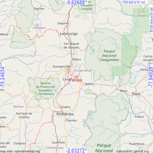
Pelileo GPS coordinates[2]
1° 19' 47.64" South, 78° 32' 36.276" West
| Map corner | latitude | longitude |
|---|---|---|
| Upper-left | -0.62688°, | -79.24654° |
| Center: | -1.3299°, | -78.54341° |
| Lower-right: | -2.03272°, | -77.84029° |
| Map W x H: | 156.3×156.3 km | = 97.1×97.1mi |
| max Lat: | 1.35251° ⇑44.6% North |
| Pelileo: | -1.3299° |
| min Lat: | ⇓55.4% South -4.38181° |
| min Long | Pelileo | max Long |
| -90.96654° | -78.54341° | -76.89528° |
| W 78.5%⇐ | ⇒21.5% E |
Elevation
Elevation of Pelileo is 2589 m = 8494 ft, and this is 1643.9 m = 5393 ft above average elevation for this country.
| Max E: |
3131 m = 10272 ft | 15.7% |
| Pelileo | 2589 m 8494 ft | |
| Avg. | 945.1 m = 3101 ft | |
Min E: |
1 m = 3 ft | 84.3% |
See also: Ecuador elevation on elevation.city.
Geographical zone
Pelileo is located in South Torrid zone (between Equator and Tropic of Capricorn). Distance of Equator is 147.9 km =91.9 mi to North.| Distance of | km | miles | from Pelileo |
|---|---|---|---|
| Equator | 147.9 | 91.9 | to North |
| Tropic Capricorn | 2458 | 1527.3 | to South |
| Antarctic Circle | 7253.3 | 4507 | to South |
| South Pole | 9859.2 | 6126.2 | to South |


Nearby cities:
15 places around Pelileo: (largest is in red/bold)
• Ambato
12.1 km =7.5 mi,  317°
317°
• Baños
15.3 km =9.5 mi,  119°
119°
• Guano
32.4 km =20.1 mi,  197°
197°
• Guaranda
58.7 km =36.5 mi,  240°
240°
• Latacunga
44.6 km =27.7 mi,  349°
349°
• Palora
76.4 km =47.5 mi, 122°
• Pujilí
44.8 km =27.8 mi,  337°
337°
• Puyo
62.5 km =38.8 mi,  105°
105°
• Píllaro
17.3 km =10.7 mi,  358°
358°
• Quero
9.2 km =5.7 mi,  231°
231°
• Riobamba
39.6 km =24.6 mi, 196°
• San Miguel
69.7 km =43.3 mi, 232°
• San Miguel de Salcedo
32.1 km =19.9 mi, 350°
• Santa Clara
73.3 km =45.5 mi,  84°
84°
• Saquisilí
56.2 km =34.9 mi, 345°
Sources, notices
• [Note1] Compared only with cities in Ecuador existing in our database
• [Src1] Map data: © OpenStreetMap contributors (CC-BY-SA)
• [Src2] Other city data from geonames.org with taken over terms of usage.
• [Src3] Geographical zone / Annual Mean Temperature by Robert A. Rohde @ Wikipedia
