Píllaro geodata
Píllaro (Tungurahua) is a populated place; located in Ecuador in America/Guayaquil (GMT-5) time zone. With population of 7,462 people, there are 96 cities with bigger population in this country. Compared to other cities in Ecuador, 59.5% of cities are located further ↓South; 77.7% of cities are located further ←West and 90.1% of cities have lower elevation than Píllaro. Note1


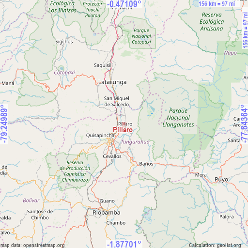
Píllaro GPS coordinates[2]
1° 10' 26.904" South, 78° 32' 48.336" West
| Map corner | latitude | longitude |
|---|---|---|
| Upper-left | -0.47109°, | -79.24989° |
| Center: | -1.17414°, | -78.54676° |
| Lower-right: | -1.87701°, | -77.84364° |
| Map W x H: | 156.3×156.3 km | = 97.1×97.1mi |
| max Lat: | 1.35251° ⇑40.5% North |
| Píllaro: | -1.17414° |
| min Lat: | ⇓59.5% South -4.38181° |
| min Long | Píllaro | max Long |
| -90.96654° | -78.54676° | -76.89528° |
| W 77.7%⇐ | ⇒22.3% E |
Elevation
Elevation of Píllaro is 2787 m = 9144 ft, and this is 1841.9 m = 6043 ft above average elevation for this country.
| Max E: |
3131 m = 10272 ft | 9.9% |
| Píllaro | 2787 m 9144 ft | |
| Avg. | 945.1 m = 3101 ft | |
Min E: |
1 m = 3 ft | 90.1% |
See also: Ecuador elevation on elevation.city.
Geographical zone
Píllaro is located in South Torrid zone (between Equator and Tropic of Capricorn). Distance of Equator is 130.6 km =81.2 mi to North.| Distance of | km | miles | from Píllaro |
|---|---|---|---|
| Equator | 130.6 | 81.2 | to North |
| Tropic Capricorn | 2475.4 | 1538.1 | to South |
| Antarctic Circle | 7270.6 | 4517.7 | to South |
| South Pole | 9876.5 | 6137 | to South |


Nearby cities:
15 places around Píllaro: (largest is in red/bold)
• Ambato
11.4 km =7.1 mi,  223°
223°
• Baños
28.3 km =17.6 mi,  150°
150°
• Guano
49.1 km =30.5 mi,  190°
190°
• Guaranda
68.7 km =42.7 mi,  227°
227°
• La Maná
79.7 km =49.5 mi,  288°
288°
• Latacunga
27.6 km =17.1 mi,  343°
343°
• Machachi
73.9 km =45.9 mi,  358°
358°
• Pelileo
17.3 km =10.7 mi,  178°
178°
• Pujilí
29.3 km =18.2 mi,  325°
325°
• Puyo
69.6 km =43.2 mi,  119°
119°
• Quero
24 km =14.9 mi,  196°
196°
• Riobamba
56.4 km =35 mi, 191°
• San Miguel de Salcedo
15.1 km =9.4 mi, 341°
• Santa Clara
74 km =46 mi,  97°
97°
• Saquisilí
39.5 km =24.5 mi, 340°
Sources, notices
• [Note1] Compared only with cities in Ecuador existing in our database
• [Src1] Map data: © OpenStreetMap contributors (CC-BY-SA)
• [Src2] Other city data from geonames.org with taken over terms of usage.
• [Src3] Geographical zone / Annual Mean Temperature by Robert A. Rohde @ Wikipedia
