San Miguel de Salcedo geodata
San Miguel de Salcedo (Cotopaxi) is a populated place; located in Ecuador in America/Guayaquil (GMT-5) time zone. With population of 10,838 people, there are 80 cities with bigger population in this country. Compared to other cities in Ecuador, 62% of cities are located further ↓South; 75.2% of cities are located further ←West and 86% of cities have lower elevation than San Miguel de Salcedo. Note1
Current local time in San Miguel de Salcedo:
12:17 AM, SaturdayDifference from your time zone: hours


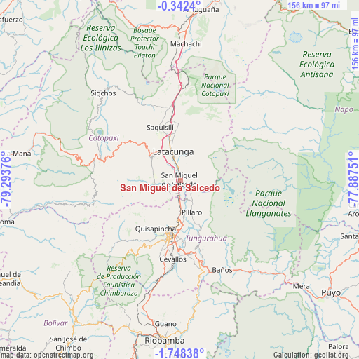
San Miguel de Salcedo GPS coordinates[2]
1° 2' 43.692" South, 78° 35' 26.268" West
| Map corner | latitude | longitude |
|---|---|---|
| Upper-left | -0.3424°, | -79.29376° |
| Center: | -1.04547°, | -78.59063° |
| Lower-right: | -1.74838°, | -77.88751° |
| Map W x H: | 156.3×156.3 km | = 97.1×97.1mi |
| max Lat: | 1.35251° ⇑38% North |
| San Miguel de Salcedo: | -1.04547° |
| min Lat: | ⇓62% South -4.38181° |
| min Long | San Miguel de S | max Long |
| -90.96654° | -78.59063° | -76.89528° |
| W 75.2%⇐ | ⇒24.8% E |
Elevation
Elevation of San Miguel de Salcedo is 2650 m = 8694 ft, and this is 1704.9 m = 5594 ft above average elevation for this country.
| Max E: |
3131 m = 10272 ft | 14% |
| San Miguel de Salcedo | 2650 m 8694 ft | |
| Avg. | 945.1 m = 3101 ft | |
Min E: |
1 m = 3 ft | 86% |
See also: Ecuador elevation on elevation.city.
Geographical zone
San Miguel de Salcedo is located in South Torrid zone (between Equator and Tropic of Capricorn). Distance of Equator is 116.2 km =72.2 mi to North.| Distance of | km | miles | from San Miguel de Salcedo |
|---|---|---|---|
| Equator | 116.2 | 72.2 | to North |
| Tropic Capricorn | 2489.7 | 1547 | to South |
| Antarctic Circle | 7284.9 | 4526.6 | to South |
| South Pole | 9890.8 | 6145.9 | to South |


Nearby cities:
15 places around San Miguel de Salcedo: (largest is in red/bold)
• Ambato
22.8 km =14.2 mi,  187°
187°
• Baños
43.3 km =26.9 mi,  154°
154°
• Guano
62.7 km =39 mi,  184°
184°
• Guaranda
76 km =47.2 mi,  216°
216°
• La Maná
71.5 km =44.4 mi,  279°
279°
• Latacunga
12.6 km =7.8 mi,  347°
347°
• Machachi
59.6 km =37 mi,  2°
2°
• Pelileo
32.1 km =19.9 mi,  170°
170°
• Pujilí
15.3 km =9.5 mi,  309°
309°
• Puyo
81.5 km =50.6 mi,  126°
126°
• Píllaro
15.1 km =9.4 mi,  161°
161°
• Quero
37.4 km =23.2 mi, 182°
• Riobamba
69.8 km =43.4 mi, 185°
• Sangolquí
80.6 km =50.1 mi,  11°
11°
• Saquisilí
24.4 km =15.2 mi,  339°
339°
Sources, notices
• [Note1] Compared only with cities in Ecuador existing in our database
• [Src1] Map data: © OpenStreetMap contributors (CC-BY-SA)
• [Src2] Other city data from geonames.org with taken over terms of usage.
• [Src3] Geographical zone / Annual Mean Temperature by Robert A. Rohde @ Wikipedia
