Tena geodata
Tena (Napo) is a seat of a first-order administrative division; located in Ecuador in America/Guayaquil (GMT-5) time zone. With population of 17,172 people, there are 56 cities with bigger population in this country. Compared to other cities in Ecuador, 64.5% of cities are located further ↓South; 93.4% of cities are located further ←West and 56.2% of cities have lower elevation than Tena. Note1


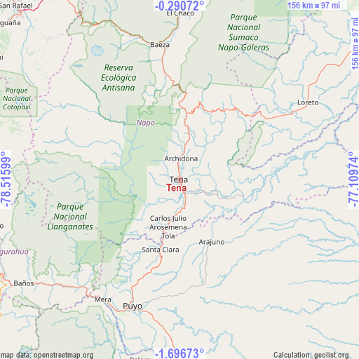
Tena GPS coordinates[2]
0° 59' 37.68" South, 77° 48' 46.296" West
| Map corner | latitude | longitude |
|---|---|---|
| Upper-left | -0.29072°, | -78.51599° |
| Center: | -0.9938°, | -77.81286° |
| Lower-right: | -1.69673°, | -77.10974° |
| Map W x H: | 156.3×156.3 km | = 97.1×97.1mi |
| max Lat: | 1.35251° ⇑35.5% North |
| Tena: | -0.9938° |
| min Lat: | ⇓64.5% South -4.38181° |
| min Long | Tena | max Long |
| -90.96654° | -77.81286° | -76.89528° |
| W 93.4%⇐ | ⇒6.6% E |
Elevation
Elevation of Tena is 504 m = 1654 ft, and this is 441.1 m = 1447 ft below average elevation for this country.
| Max E: |
3131 m = 10272 ft | 43.8% |
| Avg. | 945.1 m = 3101 ft | |
| Tena | 504 m = 1654 ft | |
Min E: |
1 m = 3 ft | 56.2% |
See also: Ecuador elevation on elevation.city.
Geographical zone
Tena is located in South Torrid zone (between Equator and Tropic of Capricorn). Distance of Equator is 110.5 km =68.7 mi to North.| Distance of | km | miles | from Tena |
|---|---|---|---|
| Equator | 110.5 | 68.7 | to North |
| Tropic Capricorn | 2495.4 | 1550.6 | to South |
| Antarctic Circle | 7290.7 | 4530.2 | to South |
| South Pole | 9896.6 | 6149.5 | to South |


Nearby cities:
15 places around Tena: (largest is in red/bold)
• Ambato
93.8 km =58.3 mi,  252°
252°
• Archidona
9.4 km =5.8 mi,  3°
3°
• Baños
81.3 km =50.5 mi,  236°
236°
• Boca Suno
81.6 km =50.7 mi,  66°
66°
• Latacunga
89.5 km =55.6 mi,  274°
274°
• Machachi
99.6 km =61.9 mi,  302°
302°
• Palora
80.5 km =50 mi,  192°
192°
• Pelileo
89.4 km =55.6 mi, 245°
• Pujilí
98.3 km =61.1 mi, 272°
• Puyo
58.4 km =36.3 mi,  201°
201°
• Píllaro
84 km =52.2 mi,  256°
256°
• Quero
98.3 km =61.1 mi, 244°
• San Miguel de Salcedo
86.7 km =53.9 mi, 266°
• Santa Clara
31.2 km =19.4 mi, 195°
• Saquisilí
96.5 km =60 mi,  280°
280°
Sources, notices
• [Note1] Compared only with cities in Ecuador existing in our database
• [Src1] Map data: © OpenStreetMap contributors (CC-BY-SA)
• [Src2] Other city data from geonames.org with taken over terms of usage.
• [Src3] Geographical zone / Annual Mean Temperature by Robert A. Rohde @ Wikipedia
