La Maná geodata
La Maná (Cotopaxi) is a populated place; located in Ecuador in America/Guayaquil (GMT-5) time zone. With population of 16,450 people, there are 61 cities with bigger population in this country. Compared to other cities in Ecuador, 67.8% of cities are located further ↓South; 54.5% of cities are located further ←West and 50.4% of cities have higher elevation than La Maná. Note1


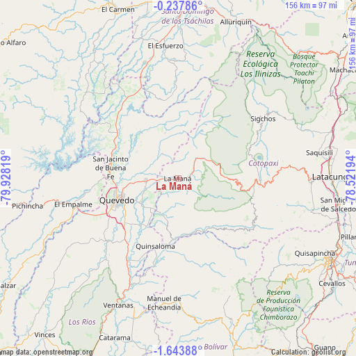
La Maná GPS coordinates[2]
0° 56' 27.384" South, 79° 13' 30.216" West
| Map corner | latitude | longitude |
|---|---|---|
| Upper-left | -0.23786°, | -79.92819° |
| Center: | -0.94094°, | -79.22506° |
| Lower-right: | -1.64388°, | -78.52194° |
| Map W x H: | 156.3×156.3 km | = 97.1×97.1mi |
| max Lat: | 1.35251° ⇑32.2% North |
| La Maná: | -0.94094° |
| min Lat: | ⇓67.8% South -4.38181° |
| min Long | La Maná | max Long |
| -90.96654° | -79.22506° | -76.89528° |
| W 54.5%⇐ | ⇒45.5% E |
Elevation
Elevation of La Maná is 212 m = 696 ft, and this is 733.1 m = 2405 ft below average elevation for this country.
| Max E: |
3131 m = 10272 ft | 50.4% |
| Avg. | 945.1 m = 3101 ft | |
| La Maná | 212 m = 696 ft | |
Min E: |
1 m = 3 ft | 49.6% |
See also: Ecuador elevation on elevation.city.
Geographical zone
La Maná is located in South Torrid zone (between Equator and Tropic of Capricorn). Distance of Equator is 104.6 km =65 mi to North.| Distance of | km | miles | from La Maná |
|---|---|---|---|
| Equator | 104.6 | 65 | to North |
| Tropic Capricorn | 2501.3 | 1554.2 | to South |
| Antarctic Circle | 7296.6 | 4533.9 | to South |
| South Pole | 9902.4 | 6153.1 | to South |


Nearby cities:
15 places around La Maná: (largest is in red/bold)
• Ambato
75.8 km =47.1 mi,  116°
116°
• Catarama
75.2 km =46.7 mi,  200°
200°
• Guaranda
76.6 km =47.6 mi,  161°
161°
• Latacunga
67.8 km =42.1 mi,  89°
89°
• Palenque
80.9 km =50.3 mi,  226°
226°
• Pujilí
58.8 km =36.5 mi, 91°
• Píllaro
79.7 km =49.5 mi,  108°
108°
• Quero
84.3 km =52.4 mi,  125°
125°
• Quevedo
28.2 km =17.5 mi,  249°
249°
• San Miguel de Salcedo
71.5 km =44.4 mi,  99°
99°
• Santo Domingo de los Colorados
76.7 km =47.7 mi,  4°
4°
• Saquisilí
63.1 km =39.2 mi,  79°
79°
• Velasco Ibarra
47.3 km =29.4 mi,  256°
256°
• Ventanas
61.5 km =38.2 mi,  205°
205°
• Wilfrido Loor Moreira
81.3 km =50.5 mi,  323°
323°
Sources, notices
• [Note1] Compared only with cities in Ecuador existing in our database
• [Src1] Map data: © OpenStreetMap contributors (CC-BY-SA)
• [Src2] Other city data from geonames.org with taken over terms of usage.
• [Src3] Geographical zone / Annual Mean Temperature by Robert A. Rohde @ Wikipedia
