Gualaquiza geodata
Gualaquiza (Morona-Santiago) is a populated place; located in Ecuador in America/Guayaquil (GMT-5) time zone. With population of 4,611 people, there are 105 cities with bigger population in this country. Compared to other cities in Ecuador, 89.3% of cities are located further ↑North; 76% of cities are located further ←West and 62.8% of cities have lower elevation than Gualaquiza. Note1


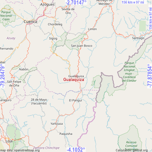
Gualaquiza GPS coordinates[2]
3° 24' 12.924" South, 78° 34' 53.976" West
| Map corner | latitude | longitude |
|---|---|---|
| Upper-left | -2.70147°, | -79.28479° |
| Center: | -3.40359°, | -78.58166° |
| Lower-right: | -4.1052°, | -77.87854° |
| Map W x H: | 156.1×156.1 km | = 97×97mi |
| max Lat: | 1.35251° ⇑89.3% North |
| Gualaquiza: | -3.40359° |
| min Lat: | ⇓10.7% South -4.38181° |
| min Long | Gualaquiza | max Long |
| -90.96654° | -78.58166° | -76.89528° |
| W 76%⇐ | ⇒24% E |
Elevation
Elevation of Gualaquiza is 851 m = 2792 ft, and this is 94.1 m = 309 ft below average elevation for this country.
| Max E: |
3131 m = 10272 ft | 37.2% |
| Avg. | 945.1 m = 3101 ft | |
| Gualaquiza | 851 m = 2792 ft | |
Min E: |
1 m = 3 ft | 62.8% |
See also: Ecuador elevation on elevation.city.
Geographical zone
Gualaquiza is located in South Torrid zone (between Equator and Tropic of Capricorn). Distance of Equator is 378.4 km =235.1 mi to North.| Distance of | km | miles | from Gualaquiza |
|---|---|---|---|
| Equator | 378.4 | 235.1 | to North |
| Tropic Capricorn | 2227.5 | 1384.1 | to South |
| Antarctic Circle | 7022.7 | 4363.7 | to South |
| South Pole | 9628.6 | 5982.9 | to South |


Nearby cities:
15 places around Gualaquiza: (largest is in red/bold)
• Azogues
79.5 km =49.4 mi,  338°
338°
• Catamayo
107.9 km =67 mi,  233°
233°
• Cañar
101.8 km =63.3 mi, 337°
• Cuenca
73 km =45.4 mi,  319°
319°
• Gualaceo
60.9 km =37.8 mi, 338°
• La Unión
65.5 km =40.7 mi, 340°
• Llacao
68.5 km =42.6 mi,  330°
330°
• Loja
95.2 km =59.2 mi, 226°
• Nulti
61.8 km =38.4 mi, 331°
• Piñas
125.8 km =78.2 mi,  255°
255°
• Portovelo
120.7 km =75 mi,  252°
252°
• Sucúa
114.5 km =71.1 mi,  23°
23°
• Yantzaza
51.7 km =32.1 mi,  202°
202°
• Zamora
84.6 km =52.6 mi,  209°
209°
• Zaruma
118.7 km =73.8 mi, 254°
Sources, notices
• [Note1] Compared only with cities in Ecuador existing in our database
• [Src1] Map data: © OpenStreetMap contributors (CC-BY-SA)
• [Src2] Other city data from geonames.org with taken over terms of usage.
• [Src3] Geographical zone / Annual Mean Temperature by Robert A. Rohde @ Wikipedia
