Yantzaza geodata
Yantzaza (Zamora-Chinchipe) is a populated place; located in Ecuador in America/Guayaquil (GMT-5) time zone. With population of 9,970 people, there are 82 cities with bigger population in this country. Compared to other cities in Ecuador, 94.2% of cities are located further ↑North; 68.6% of cities are located further ←West and 61.2% of cities have lower elevation than Yantzaza. Note1
Administrative division(s):
- Level 1: Zamora-Chinchipe
- Level 2: Cantón Yantzaza
- Level 3: Yantzaza (Yanzatza)


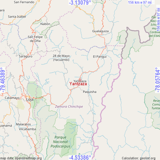
Yantzaza GPS coordinates[2]
3° 49' 57.396" South, 78° 45' 38.736" West
| Map corner | latitude | longitude |
|---|---|---|
| Upper-left | -3.13079°, | -79.46389° |
| Center: | -3.83261°, | -78.76076° |
| Lower-right: | -4.53386°, | -78.05764° |
| Map W x H: | 156×156 km | = 96.9×96.9mi |
| max Lat: | 1.35251° ⇑94.2% North |
| Yantzaza: | -3.83261° |
| min Lat: | ⇓5.8% South -4.38181° |
| min Long | Yantzaza | max Long |
| -90.96654° | -78.76076° | -76.89528° |
| W 68.6%⇐ | ⇒31.4% E |
Elevation
Elevation of Yantzaza is 826 m = 2710 ft, and this is 119.1 m = 391 ft below average elevation for this country.
| Max E: |
3131 m = 10272 ft | 38.8% |
| Avg. | 945.1 m = 3101 ft | |
| Yantzaza | 826 m = 2710 ft | |
Min E: |
1 m = 3 ft | 61.2% |
See also: Ecuador elevation on elevation.city.
Geographical zone
Yantzaza is located in South Torrid zone (between Equator and Tropic of Capricorn). Distance of Equator is 426.1 km =264.8 mi to North.| Distance of | km | miles | from Yantzaza |
|---|---|---|---|
| Equator | 426.1 | 264.8 | to North |
| Tropic Capricorn | 2179.8 | 1354.5 | to South |
| Antarctic Circle | 6975 | 4334.1 | to South |
| South Pole | 9580.9 | 5953.3 | to South |


Nearby cities:
15 places around Yantzaza: (largest is in red/bold)
• Azogues
121.9 km =75.7 mi,  355°
355°
• Cariamanga
103.9 km =64.6 mi,  238°
238°
• Catacocha
101.5 km =63.1 mi,  256°
256°
• Catamayo
68.5 km =42.6 mi, 255°
• Cuenca
107.1 km =66.5 mi,  345°
345°
• Gualaceo
104.5 km =64.9 mi, 358°
• Gualaquiza
51.7 km =32.1 mi,  22°
22°
• La Unión
109.3 km =67.9 mi, 358°
• Llacao
108.3 km =67.3 mi, 352°
• Loja
52.3 km =32.5 mi,  250°
250°
• Nulti
102.3 km =63.6 mi, 354°
• Piñas
103.5 km =64.3 mi,  279°
279°
• Portovelo
96.3 km =59.8 mi, 277°
• Zamora
33.8 km =21 mi,  219°
219°
• Zaruma
95.7 km =59.5 mi, 279°
Sources, notices
• [Note1] Compared only with cities in Ecuador existing in our database
• [Src1] Map data: © OpenStreetMap contributors (CC-BY-SA)
• [Src2] Other city data from geonames.org with taken over terms of usage.
• [Src3] Geographical zone / Annual Mean Temperature by Robert A. Rohde @ Wikipedia
