Bilqās geodata
Bilqās (Dakahlia) is a populated place; located in Egypt in Africa/Cairo (GMT+2) time zone. With population of 103,596 people, there are 34 cities with bigger population in this country. Compared to other cities in Egypt, 92% of cities are located further ↓South; 52.2% of cities are located further ←West and 68.1% of cities have higher elevation than Bilqās. Note1


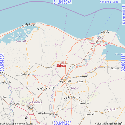
Bilqās GPS coordinates[2]
31° 12' 52.272" North, 31° 21' 28.728" East
| Map corner | latitude | longitude |
|---|---|---|
| Upper-left | 31.81394°, | 30.65486° |
| Center: | 31.21452°, | 31.35798° |
| Lower-right: | 30.61128°, | 32.06111° |
| Map W x H: | 133.7×133.7 km | = 83.1×83.1mi |
| max Lat: | 31.5084° ⇑8% North |
| Bilqās: | 31.21452° |
| min Lat: | ⇓92% South 22.3457° |
| min Long | Bilqās | max Long |
| 25.51965° | 31.35798° | 34.89572° |
| W 52.2%⇐ | ⇒47.8% E |
Elevation
Elevation of Bilqās is 13 m = 43 ft, and this is 30.5 m = 100 ft below average elevation for this country.
| Max E: |
1565 m = 5135 ft | 68.1% |
| Avg. | 43.5 m = 143 ft | |
| Bilqās | 13 m = 43 ft | |
Min E: |
-15 m = -49 ft | 31.9% |
See also: Bilqās elevation on elevation.city.
Geographical zone
Bilqās is located in North temperate zone (between Tropic of Cancer and the Arctic Circle). Distance of this Northern Tropic circle is 864.8 km =537.4 mi to South.| Distance of | km | miles | from Bilqās |
|---|---|---|---|
| North Pole | 6536.3 | 4061.5 | to North |
| Arctic Circle | 3930.4 | 2442.2 | to North |
| Tropic Cancer | 864.8 | 537.4 | to South |
| Equator | 3470.7 | 2156.6 | to South |


Nearby cities:
15 places around Bilqās: (largest is in red/bold)
• Ajā
31 km =19.3 mi,  191°
191°
• Al Jammālīyah
48.4 km =30.1 mi,  94°
94°
• Al Manşūrah
19.9 km =12.4 mi,  173°
173°
• Al Maḩallah al Kubrá
32.7 km =20.3 mi,  213°
213°
• Al Ḩāmūl
22.7 km =14.1 mi,  298°
298°
• Az Zarqā
26.4 km =16.4 mi, 91°
• Damietta
48.7 km =30.3 mi,  62°
62°
• Dikirnis
26.5 km =16.5 mi,  121°
121°
• Fāraskūr
36.3 km =22.6 mi,  69°
69°
• Kafr ash Shaykh
41.4 km =25.7 mi,  253°
253°
• Minyat an Naşr
28.8 km =17.9 mi,  109°
109°
• Quţūr
46.8 km =29.1 mi,  234°
234°
• Samannūd
30.3 km =18.8 mi,  201°
201°
• Shirbīn
15.9 km =9.9 mi,  97°
97°
• Ţalkhā
18 km =11.2 mi, 173°
Sources, notices
• [Note1] Compared only with cities in Egypt existing in our database
• [Src1] Map data: © OpenStreetMap contributors (CC-BY-SA)
• [Src2] Other city data from geonames.org with taken over terms of usage.
• [Src3] Geographical zone / Annual Mean Temperature by Robert A. Rohde @ Wikipedia
