Fāraskūr geodata
Fāraskūr (Damietta) is a populated place; located in Egypt in Africa/Cairo (GMT+2) time zone. With population of 58,284 people, there are 72 cities with bigger population in this country. Compared to other cities in Egypt, 97.1% of cities are located further ↓South; 68.8% of cities are located further ←West and 61.6% of cities have higher elevation than Fāraskūr. Note1


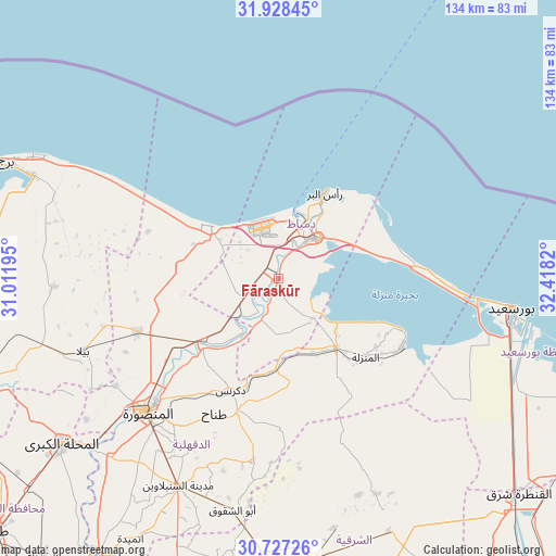
Fāraskūr GPS coordinates[2]
31° 19' 47.172" North, 31° 42' 54.252" East
| Map corner | latitude | longitude |
|---|---|---|
| Upper-left | 31.92845°, | 31.01195° |
| Center: | 31.32977°, | 31.71507° |
| Lower-right: | 30.72726°, | 32.4182° |
| Map W x H: | 133.6×133.6 km | = 83×83mi |
| max Lat: | 31.5084° ⇑2.9% North |
| Fāraskūr: | 31.32977° |
| min Lat: | ⇓97.1% South 22.3457° |
| min Long | Fāraskūr | max Long |
| 25.51965° | 31.71507° | 34.89572° |
| W 68.8%⇐ | ⇒31.2% E |
Elevation
Elevation of Fāraskūr is 15 m = 49 ft, and this is 28.5 m = 94 ft below average elevation for this country.
| Max E: |
1565 m = 5135 ft | 61.6% |
| Avg. | 43.5 m = 143 ft | |
| Fāraskūr | 15 m = 49 ft | |
Min E: |
-15 m = -49 ft | 38.4% |
See also: Fāraskūr elevation on elevation.city.
Geographical zone
Fāraskūr is located in North temperate zone (between Tropic of Cancer and the Arctic Circle). Distance of this Northern Tropic circle is 877.6 km =545.3 mi to South.| Distance of | km | miles | from Fāraskūr |
|---|---|---|---|
| North Pole | 6523.5 | 4053.5 | to North |
| Arctic Circle | 3917.6 | 2434.3 | to North |
| Tropic Cancer | 877.6 | 545.3 | to South |
| Equator | 3483.5 | 2164.5 | to South |


Nearby cities:
15 places around Fāraskūr: (largest is in red/bold)
• Ajā
59.1 km =36.7 mi,  223°
223°
• Al Jammālīyah
21.9 km =13.6 mi,  139°
139°
• Al Manzalah
28.4 km =17.6 mi,  132°
132°
• Al Manşūrah
45.6 km =28.3 mi, 224°
• Al Maţarīyah
34.2 km =21.3 mi,  118°
118°
• Al Ḩāmūl
53.9 km =33.5 mi,  267°
267°
• Az Zarqā
15.5 km =9.6 mi,  209°
209°
• Bilqās
36.3 km =22.6 mi,  249°
249°
• Damietta
13.4 km =8.3 mi,  44°
44°
• Dikirnis
29.1 km =18.1 mi,  203°
203°
• Minyat an Naşr
23.6 km =14.7 mi, 196°
• Port Said
54.7 km =34 mi,  98°
98°
• Shirbīn
23.4 km =14.5 mi,  230°
230°
• Ţalkhā
44.4 km =27.6 mi, 226°
• ‘Izbat al Burj
23.2 km =14.4 mi,  31°
31°
Sources, notices
• [Note1] Compared only with cities in Egypt existing in our database
• [Src1] Map data: © OpenStreetMap contributors (CC-BY-SA)
• [Src2] Other city data from geonames.org with taken over terms of usage.
• [Src3] Geographical zone / Annual Mean Temperature by Robert A. Rohde @ Wikipedia
