Al Jammālīyah geodata
Al Jammālīyah (Dakahlia) is a populated place; located in Egypt in Africa/Cairo (GMT+2) time zone. With population of 68,381 people, there are 55 cities with bigger population in this country. Compared to other cities in Egypt, 87.7% of cities are located further ↓South; 74.6% of cities are located further ←West and 81.2% of cities have higher elevation than Al Jammālīyah. Note1


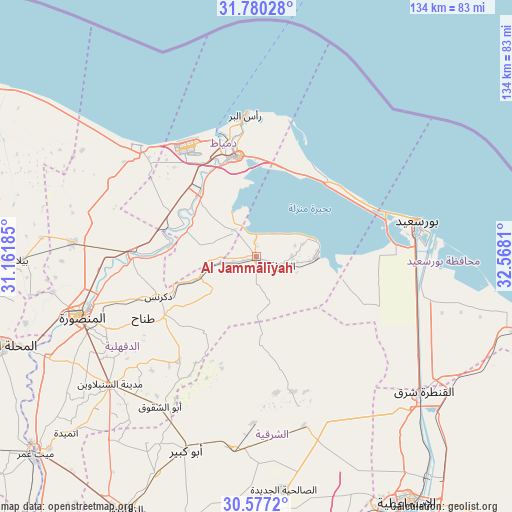
Al Jammālīyah GPS coordinates[2]
31° 10' 50.34" North, 31° 51' 53.892" East
| Map corner | latitude | longitude |
|---|---|---|
| Upper-left | 31.78028°, | 31.16185° |
| Center: | 31.18065°, | 31.86497° |
| Lower-right: | 30.5772°, | 32.5681° |
| Map W x H: | 133.8×133.8 km | = 83.1×83.1mi |
| max Lat: | 31.5084° ⇑12.3% North |
| Al Jammālīyah: | 31.18065° |
| min Lat: | ⇓87.7% South 22.3457° |
| min Long | Al Jammālīyah | max Long |
| 25.51965° | 31.86497° | 34.89572° |
| W 74.6%⇐ | ⇒25.4% E |
Elevation
Elevation of Al Jammālīyah is 11 m = 36 ft, and this is 32.5 m = 107 ft below average elevation for this country.
| Max E: |
1565 m = 5135 ft | 81.2% |
| Avg. | 43.5 m = 143 ft | |
| Al Jammālīyah | 11 m = 36 ft | |
Min E: |
-15 m = -49 ft | 18.8% |
See also: Al Jammālīyah elevation on elevation.city.
Geographical zone
Al Jammālīyah is located in North temperate zone (between Tropic of Cancer and the Arctic Circle). Distance of this Northern Tropic circle is 861 km =535 mi to South.| Distance of | km | miles | from Al Jammālīyah |
|---|---|---|---|
| North Pole | 6540.1 | 4063.8 | to North |
| Arctic Circle | 3934.2 | 2444.6 | to North |
| Tropic Cancer | 861 | 535 | to South |
| Equator | 3467 | 2154.3 | to South |


Nearby cities:
15 places around Al Jammālīyah: (largest is in red/bold)
• Al Manzalah
7.2 km =4.5 mi,  110°
110°
• Al Manşūrah
48.8 km =30.3 mi,  250°
250°
• Al Maţarīyah
15.8 km =9.8 mi,  89°
89°
• Az Zarqā
22.1 km =13.7 mi,  278°
278°
• Bilqās
48.4 km =30.1 mi,  274°
274°
• Damietta
26.7 km =16.6 mi,  349°
349°
• Dikirnis
27.7 km =17.2 mi, 248°
• Fāqūs
50.7 km =31.5 mi,  187°
187°
• Fāraskūr
21.9 km =13.6 mi,  319°
319°
• Kafr Şaqr
48.7 km =30.3 mi,  207°
207°
• Minyat an Naşr
22 km =13.7 mi, 254°
• Port Said
40.7 km =25.3 mi,  78°
78°
• Shirbīn
32.5 km =20.2 mi, 273°
• Ţalkhā
48.5 km =30.1 mi, 253°
• ‘Izbat al Burj
36.5 km =22.7 mi,  356°
356°
Sources, notices
• [Note1] Compared only with cities in Egypt existing in our database
• [Src1] Map data: © OpenStreetMap contributors (CC-BY-SA)
• [Src2] Other city data from geonames.org with taken over terms of usage.
• [Src3] Geographical zone / Annual Mean Temperature by Robert A. Rohde @ Wikipedia
