Damietta geodata
Damietta is a seat of a first-order administrative division; located in Egypt in Africa/Cairo (GMT+2) time zone. With population of 76,839 people, there are 49 cities with bigger population in this country. Compared to other cities in Egypt, 99.3% of cities are located further ↓South; 73.2% of cities are located further ←West and 55.1% of cities have higher elevation than Damietta. Note1


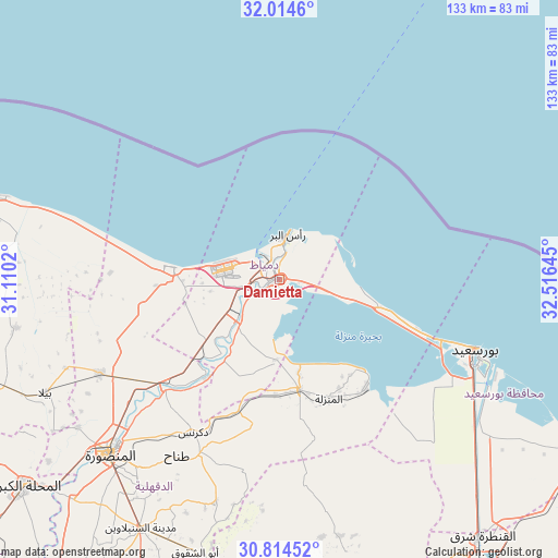
Damietta GPS coordinates[2]
31° 24' 59.328" North, 31° 48' 47.952" East
| Map corner | latitude | longitude |
|---|---|---|
| Upper-left | 32.0146°, | 31.1102° |
| Center: | 31.41648°, | 31.81332° |
| Lower-right: | 30.81452°, | 32.51645° |
| Map W x H: | 133.4×133.4 km | = 82.9×82.9mi |
| max Lat: | 31.5084° ⇑0.7% North |
| Damietta: | 31.41648° |
| min Lat: | ⇓99.3% South 22.3457° |
| min Long | Damietta | max Long |
| 25.51965° | 31.81332° | 34.89572° |
| W 73.2%⇐ | ⇒26.8% E |
Elevation
Elevation of Damietta is 16 m = 52 ft, and this is 27.5 m = 90 ft below average elevation for this country.
| Max E: |
1565 m = 5135 ft | 55.1% |
| Avg. | 43.5 m = 143 ft | |
| Damietta | 16 m = 52 ft | |
Min E: |
-15 m = -49 ft | 44.9% |
See also: Damietta elevation on elevation.city.
Geographical zone
Damietta is located in North temperate zone (between Tropic of Cancer and the Arctic Circle). Distance of this Northern Tropic circle is 887.3 km =551.3 mi to South.| Distance of | km | miles | from Damietta |
|---|---|---|---|
| North Pole | 6513.9 | 4047.5 | to North |
| Arctic Circle | 3908 | 2428.3 | to North |
| Tropic Cancer | 887.3 | 551.3 | to South |
| Equator | 3493.2 | 2170.6 | to South |


Nearby cities:
15 places around Damietta: (largest is in red/bold)
• Al Jammālīyah
26.7 km =16.6 mi,  169°
169°
• Al Manzalah
31 km =19.3 mi,  157°
157°
• Al Manşūrah
59 km =36.7 mi,  224°
224°
• Al Maţarīyah
33.2 km =20.6 mi,  141°
141°
• Al Ḩāmūl
64.3 km =40 mi,  259°
259°
• Az Zarqā
28.6 km =17.8 mi, 216°
• Bilqās
48.7 km =30.3 mi,  242°
242°
• Dikirnis
41.9 km =26 mi,  209°
209°
• Fāraskūr
13.4 km =8.3 mi, 224°
• Kafr Şaqr
71.5 km =44.4 mi,  194°
194°
• Minyat an Naşr
36.1 km =22.4 mi, 206°
• Port Said
48.1 km =29.9 mi,  111°
111°
• Shirbīn
36.7 km =22.8 mi,  228°
228°
• Ţalkhā
57.8 km =35.9 mi, 225°
• ‘Izbat al Burj
10.6 km =6.6 mi,  14°
14°
In other languages:
- In Spanish: Damieta
- In France: Damiette
- In German: Damiette
- In Russian: Думъят
- In Chinese: 杜姆亚特
Sources, notices
• [Note1] Compared only with cities in Egypt existing in our database
• [Src1] Map data: © OpenStreetMap contributors (CC-BY-SA)
• [Src2] Other city data from geonames.org with taken over terms of usage.
• [Src3] Geographical zone / Annual Mean Temperature by Robert A. Rohde @ Wikipedia
