Villarrubia de Santiago geodata
Villarrubia de Santiago (Castille-La Mancha) is a seat of a third-order administrative division; located in Spain in Europe/Madrid (GMT+2) time zone. With population of 2,852 people, there are 1771 cities with bigger population in this country. Compared to other cities in Spain, 70.4% of cities are located further ↑North; 50.4% of cities are located further →East and 62.1% of cities have lower elevation than Villarrubia de Santiago. Note1
Administrative division(s):
- Level 1: Castille-La Mancha
- Level 2: Province of Toledo
- Level 3: Villarrubia de Santiago
Current local time in Villarrubia de Santiago:
10:39 PM, ThursdayDifference from your time zone: hours


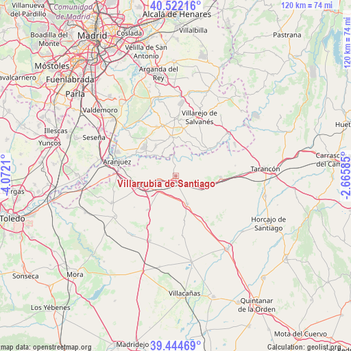
Villarrubia de Santiago GPS coordinates[2]
39° 59' 7.98" North, 3° 22' 8.328" West
| Map corner | latitude | longitude |
|---|---|---|
| Upper-left | 40.52216°, | -4.0721° |
| Center: | 39.98555°, | -3.36898° |
| Lower-right: | 39.44469°, | -2.66585° |
| Map W x H: | 119.8×119.8 km | = 74.4×74.4mi |
| max Lat: | 43.74134° ⇑70.4% North |
| Villarrubia de Santiago: | 39.98555° |
| min Lat: | ⇓29.6% South 27.64134° |
| min Long | Villarrubia de | max Long |
| -18.00367° | -3.36898° | 4.2899° |
| W 49.6%⇐ | ⇒50.4% E |
Elevation
Elevation of Villarrubia de Santiago is 758 m = 2487 ft, and this is 160 m = 525 ft above average elevation for this country.
| Max E: |
1682 m = 5518 ft | 37.9% |
| Villarrubia de Santiago | 758 m 2487 ft | |
| Avg. | 598 m = 1962 ft | |
Min E: |
0 m = 0 ft | 62.1% |
See also: Spain elevation on elevation.city.
Geographical zone
Villarrubia de Santiago is located in North temperate zone (between Tropic of Cancer and the Arctic Circle). Distance of this Northern Tropic circle is 1840.1 km =1143.4 mi to South.| Distance of | km | miles | from Villarrubia de Santiago |
|---|---|---|---|
| North Pole | 5561.1 | 3455.5 | to North |
| Arctic Circle | 2955.2 | 1836.3 | to North |
| Tropic Cancer | 1840.1 | 1143.4 | to South |
| Equator | 4446 | 2762.6 | to South |


Nearby cities:
15 places around Villarrubia de Santiago: (largest is in red/bold)
• Aranjuez
20.5 km =12.7 mi,  284°
284°
• Belmonte de Tajo
16.5 km =10.3 mi,  9°
9°
• Cabañas de Yepes
17.7 km =11 mi,  233°
233°
• Chinchón
17.8 km =11.1 mi,  345°
345°
• Ciruelos
21.5 km =13.4 mi,  256°
256°
• Colmenar de Oreja
13.5 km =8.4 mi, 354°
• Dosbarrios
15.1 km =9.4 mi,  220°
220°
• Noblejas
6.1 km =3.8 mi, 264°
• Ocaña
11.4 km =7.1 mi,  254°
254°
• Ontígola
17.4 km =10.8 mi, 276°
• Santa Cruz de la Zarza
15.4 km =9.6 mi,  91°
91°
• Villaconejos
16.1 km =10 mi,  323°
323°
• Villamanrique de Tajo
14.4 km =8.9 mi,  51°
51°
• Villatobas
10.1 km =6.3 mi,  157°
157°
• Zarza de Tajo
20.7 km =12.9 mi,  80°
80°
Sources, notices
• [Note1] Compared only with cities in Spain existing in our database
• [Src1] Map data: © OpenStreetMap contributors (CC-BY-SA)
• [Src2] Other city data from geonames.org with taken over terms of usage.
• [Src3] Geographical zone / Annual Mean Temperature by Robert A. Rohde @ Wikipedia
