Villatobas geodata
Villatobas (Castille-La Mancha) is a seat of a third-order administrative division; located in Spain in Europe/Madrid (GMT+2) time zone. With population of 2,356 people, there are 1966 cities with bigger population in this country. Compared to other cities in Spain, 71.5% of cities are located further ↑North; 50.2% of cities are located further ←West and 58.9% of cities have lower elevation than Villatobas. Note1
Administrative division(s):
- Level 1: Castille-La Mancha
- Level 2: Province of Toledo
- Level 3: Villatobas


Villatobas GPS coordinates[2]
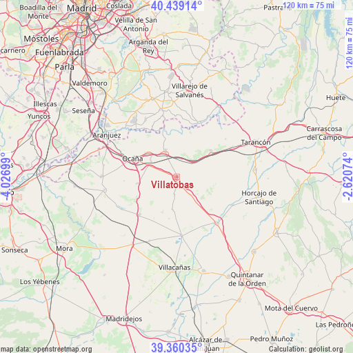
39° 54' 6.732" North, 3° 19' 25.896" West
| Map corner | latitude | longitude |
|---|---|---|
| Upper-left | 40.43914°, | -4.02699° |
| Center: | 39.90187°, | -3.32386° |
| Lower-right: | 39.36035°, | -2.62074° |
| Map W x H: | 120×119.9 km | = 74.6×74.5mi |
| max Lat: | 43.74134° ⇑71.5% North |
| Villatobas: | 39.90187° |
| min Lat: | ⇓28.5% South 27.64134° |
| min Long | Villatobas | max Long |
| -18.00367° | -3.32386° | 4.2899° |
| W 50.2%⇐ | ⇒49.8% E |
Elevation
Elevation of Villatobas is 736 m = 2415 ft, and this is 138 m = 453 ft above average elevation for this country.
| Max E: |
1682 m = 5518 ft | 41.1% |
| Villatobas | 736 m 2415 ft | |
| Avg. | 598 m = 1962 ft | |
Min E: |
0 m = 0 ft | 58.9% |
See also: Spain elevation on elevation.city.
Geographical zone
Villatobas is located in North temperate zone (between Tropic of Cancer and the Arctic Circle). Distance of this Northern Tropic circle is 1830.8 km =1137.6 mi to South.| Distance of | km | miles | from Villatobas |
|---|---|---|---|
| North Pole | 5570.4 | 3461.3 | to North |
| Arctic Circle | 2964.5 | 1842.1 | to North |
| Tropic Cancer | 1830.8 | 1137.6 | to South |
| Equator | 4436.7 | 2756.8 | to South |


Nearby cities:
15 places around Villatobas: (largest is in red/bold)
• Cabañas de Yepes
18.1 km =11.2 mi,  265°
265°
• Cabezamesada
21.2 km =13.2 mi,  116°
116°
• Colmenar de Oreja
23.4 km =14.5 mi,  347°
347°
• Corral de Almaguer
20.8 km =12.9 mi,  139°
139°
• Dosbarrios
13.9 km =8.6 mi,  260°
260°
• La Guardia
18.1 km =11.2 mi,  225°
225°
• Lillo
19.9 km =12.4 mi,  175°
175°
• Noblejas
13.2 km =8.2 mi,  311°
311°
• Ocaña
16.1 km =10 mi,  292°
292°
• Ontígola
24 km =14.9 mi,  298°
298°
• Romeral
23.6 km =14.7 mi,  203°
203°
• Santa Cruz de la Zarza
14.6 km =9.1 mi,  52°
52°
• Villamanrique de Tajo
19.7 km =12.2 mi,  22°
22°
• Villarrubia de Santiago
10.1 km =6.3 mi,  337°
337°
• Zarza de Tajo
20.9 km =13 mi, 52°
Sources, notices
• [Note1] Compared only with cities in Spain existing in our database
• [Src1] Map data: © OpenStreetMap contributors (CC-BY-SA)
• [Src2] Other city data from geonames.org with taken over terms of usage.
• [Src3] Geographical zone / Annual Mean Temperature by Robert A. Rohde @ Wikipedia
