Torreblascopedro geodata
Torreblascopedro (Andalusia) is a seat of a third-order administrative division; located in Spain in Europe/Madrid (GMT+2) time zone. With population of 2,713 people, there are 1812 cities with bigger population in this country. Compared to other cities in Spain, 88.6% of cities are located further ↑North; 54.4% of cities are located further →East and 73% of cities have higher elevation than Torreblascopedro. Note1


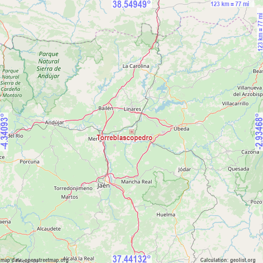
Torreblascopedro GPS coordinates[2]
37° 59' 51" North, 3° 38' 16.08" West
| Map corner | latitude | longitude |
|---|---|---|
| Upper-left | 38.54949°, | -4.34093° |
| Center: | 37.9975°, | -3.6378° |
| Lower-right: | 37.44132°, | -2.93468° |
| Map W x H: | 123.2×123.2 km | = 76.6×76.6mi |
| max Lat: | 43.74134° ⇑88.6% North |
| Torreblascopedro: | 37.9975° |
| min Lat: | ⇓11.4% South 27.64134° |
| min Long | Torreblascopedr | max Long |
| -18.00367° | -3.6378° | 4.2899° |
| W 45.6%⇐ | ⇒54.4% E |
Elevation
Elevation of Torreblascopedro is 333 m = 1093 ft, and this is 265 m = 869 ft below average elevation for this country.
| Max E: |
1682 m = 5518 ft | 73% |
| Avg. | 598 m = 1962 ft | |
| Torreblascopedro | 333 m = 1093 ft | |
Min E: |
0 m = 0 ft | 27% |
See also: Spain elevation on elevation.city.
Geographical zone
Torreblascopedro is located in North temperate zone (between Tropic of Cancer and the Arctic Circle). Distance of this Northern Tropic circle is 1619 km =1006 mi to South.| Distance of | km | miles | from Torreblascopedro |
|---|---|---|---|
| North Pole | 5782.1 | 3592.8 | to North |
| Arctic Circle | 3176.2 | 1973.6 | to North |
| Tropic Cancer | 1619 | 1006 | to South |
| Equator | 4224.9 | 2625.2 | to South |


Nearby cities:
15 places around Torreblascopedro: (largest is in red/bold)
• Baeza
14.6 km =9.1 mi,  91°
91°
• Bailén
16.5 km =10.3 mi,  311°
311°
• Baños de la Encina
23 km =14.3 mi,  328°
328°
• Begíjar
9.5 km =5.9 mi,  98°
98°
• Canena
14.7 km =9.1 mi,  66°
66°
• Cazalilla
21.5 km =13.4 mi,  265°
265°
• Espelúy
20.1 km =12.5 mi,  280°
280°
• Guarromán
21.1 km =13.1 mi,  348°
348°
• Ibros
12.1 km =7.5 mi,  77°
77°
• Jabalquinto
8 km =5 mi,  287°
287°
• Jimena
22.3 km =13.9 mi,  140°
140°
• Linares
10.9 km =6.8 mi,  0°
0°
• Lupión
8 km =5 mi, 90°
• Mengibar
15.3 km =9.5 mi,  258°
258°
• Rus
16.3 km =10.1 mi, 70°
Sources, notices
• [Note1] Compared only with cities in Spain existing in our database
• [Src1] Map data: © OpenStreetMap contributors (CC-BY-SA)
• [Src2] Other city data from geonames.org with taken over terms of usage.
• [Src3] Geographical zone / Annual Mean Temperature by Robert A. Rohde @ Wikipedia
