Begíjar geodata
Begíjar (Andalusia) is a seat of a third-order administrative division; located in Spain in Europe/Madrid (GMT+2) time zone. With population of 3,098 people, there are 1689 cities with bigger population in this country. Compared to other cities in Spain, 88.7% of cities are located further ↑North; 52.7% of cities are located further →East and 56.4% of cities have higher elevation than Begíjar. Note1


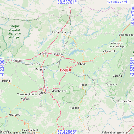
Begíjar GPS coordinates[2]
37° 59' 5.712" North, 3° 31' 51.384" West
| Map corner | latitude | longitude |
|---|---|---|
| Upper-left | 38.53701°, | -4.23406° |
| Center: | 37.98492°, | -3.53094° |
| Lower-right: | 37.42865°, | -2.82781° |
| Map W x H: | 123.2×123.2 km | = 76.6×76.6mi |
| max Lat: | 43.74134° ⇑88.7% North |
| Begíjar: | 37.98492° |
| min Lat: | ⇓11.3% South 27.64134° |
| min Long | Begíjar | max Long |
| -18.00367° | -3.53094° | 4.2899° |
| W 47.3%⇐ | ⇒52.7% E |
Elevation
Elevation of Begíjar is 575 m = 1886 ft, and this is 23 m = 75 ft below average elevation for this country.
| Max E: |
1682 m = 5518 ft | 56.4% |
| Avg. | 598 m = 1962 ft | |
| Begíjar | 575 m = 1886 ft | |
Min E: |
0 m = 0 ft | 43.6% |
See also: Spain elevation on elevation.city.
Geographical zone
Begíjar is located in North temperate zone (between Tropic of Cancer and the Arctic Circle). Distance of this Northern Tropic circle is 1617.6 km =1005.1 mi to South.| Distance of | km | miles | from Begíjar |
|---|---|---|---|
| North Pole | 5783.5 | 3593.7 | to North |
| Arctic Circle | 3177.6 | 1974.5 | to North |
| Tropic Cancer | 1617.6 | 1005.1 | to South |
| Equator | 4223.5 | 2624.4 | to South |


Nearby cities:
15 places around Begíjar: (largest is in red/bold)
• Baeza
5.3 km =3.3 mi,  79°
79°
• Canena
8.3 km =5.2 mi,  30°
30°
• Ibros
4.7 km =2.9 mi, 31°
• Jabalquinto
17.4 km =10.8 mi,  282°
282°
• Jimena
16.6 km =10.3 mi,  163°
163°
• Jódar
22.4 km =13.9 mi,  135°
135°
• Linares
15.3 km =9.5 mi,  323°
323°
• Lupión
1.9 km =1.2 mi,  312°
312°
• Mancha Real
23.2 km =14.4 mi,  197°
197°
• Rus
9.2 km =5.7 mi,  40°
40°
• Sabiote
21.1 km =13.1 mi,  63°
63°
• Torreblascopedro
9.5 km =5.9 mi, 278°
• Torreperogil
21.8 km =13.5 mi, 75°
• Torres
22.3 km =13.9 mi,  175°
175°
• Úbeda
14.4 km =8.9 mi, 77°
Sources, notices
• [Note1] Compared only with cities in Spain existing in our database
• [Src1] Map data: © OpenStreetMap contributors (CC-BY-SA)
• [Src2] Other city data from geonames.org with taken over terms of usage.
• [Src3] Geographical zone / Annual Mean Temperature by Robert A. Rohde @ Wikipedia
