Carbajo geodata
Carbajo (Extremadura) is a seat of a third-order administrative division; located in Spain in Europe/Madrid (GMT+2) time zone. With population of 248 people, there are 4751 cities with bigger population in this country. Compared to other cities in Spain, 75.7% of cities are located further ↑North; 94.7% of cities are located further →East and 72.5% of cities have higher elevation than Carbajo. Note1


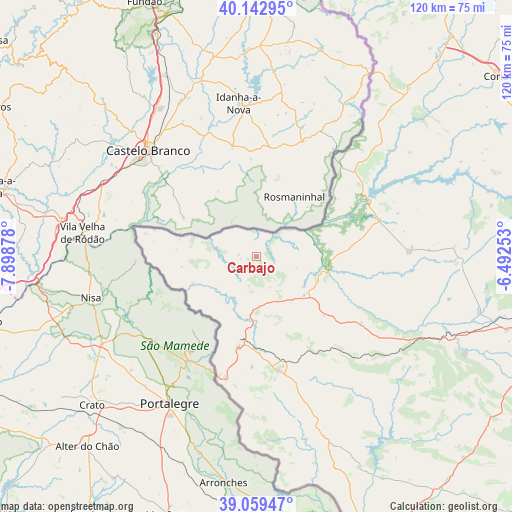
Carbajo GPS coordinates[2]
39° 36' 11.988" North, 7° 11' 44.34" West
| Map corner | latitude | longitude |
|---|---|---|
| Upper-left | 40.14295°, | -7.89878° |
| Center: | 39.60333°, | -7.19565° |
| Lower-right: | 39.05947°, | -6.49253° |
| Map W x H: | 120.5×120.5 km | = 74.9×74.9mi |
| max Lat: | 43.74134° ⇑75.7% North |
| Carbajo: | 39.60333° |
| min Lat: | ⇓24.3% South 27.64134° |
| min Long | Carbajo | max Long |
| -18.00367° | -7.19565° | 4.2899° |
| W 5.3%⇐ | ⇒94.7% E |
Elevation
Elevation of Carbajo is 339 m = 1112 ft, and this is 259 m = 850 ft below average elevation for this country.
| Max E: |
1682 m = 5518 ft | 72.5% |
| Avg. | 598 m = 1962 ft | |
| Carbajo | 339 m = 1112 ft | |
Min E: |
0 m = 0 ft | 27.5% |
See also: Spain elevation on elevation.city.
Geographical zone
Carbajo is located in North temperate zone (between Tropic of Cancer and the Arctic Circle). Distance of this Northern Tropic circle is 1797.6 km =1117 mi to South.| Distance of | km | miles | from Carbajo |
|---|---|---|---|
| North Pole | 5603.6 | 3481.9 | to North |
| Arctic Circle | 2997.7 | 1862.7 | to North |
| Tropic Cancer | 1797.6 | 1117 | to South |
| Equator | 4403.5 | 2736.2 | to South |


Nearby cities:
15 places around Carbajo: (largest is in red/bold)
• Alcántara
29.6 km =18.4 mi,  64°
64°
• Brozas
35.8 km =22.2 mi,  88°
88°
• Ceclavín
43.6 km =27.1 mi, 56°
• Cedillo
26.4 km =16.4 mi,  281°
281°
• Herrera de Alcántara
18.5 km =11.5 mi, 282°
• La Codosera
43.9 km =27.3 mi,  177°
177°
• Mata de Alcántara
34.7 km =21.6 mi,  68°
68°
• Membrío
14.8 km =9.2 mi,  124°
124°
• Piedras Albas
30.6 km =19 mi,  48°
48°
• Salorino
21.2 km =13.2 mi,  130°
130°
• San Vicente de Alcántara
27.4 km =17 mi,  169°
169°
• Santiago de Alcántara
4.2 km =2.6 mi, 275°
• Valencia de Alcántara
21.7 km =13.5 mi,  191°
191°
• Villa del Rey
32.7 km =20.3 mi,  78°
78°
• Zarza la Mayor
41.7 km =25.9 mi,  43°
43°
Sources, notices
• [Note1] Compared only with cities in Spain existing in our database
• [Src1] Map data: © OpenStreetMap contributors (CC-BY-SA)
• [Src2] Other city data from geonames.org with taken over terms of usage.
• [Src3] Geographical zone / Annual Mean Temperature by Robert A. Rohde @ Wikipedia
