Escúzar geodata
Escúzar (Andalusia) is a seat of a third-order administrative division; located in Spain in Europe/Madrid (GMT+2) time zone. With population of 745 people, there are 3316 cities with bigger population in this country. Compared to other cities in Spain, 94.9% of cities are located further ↑North; 56.2% of cities are located further →East and 77.4% of cities have lower elevation than Escúzar. Note1


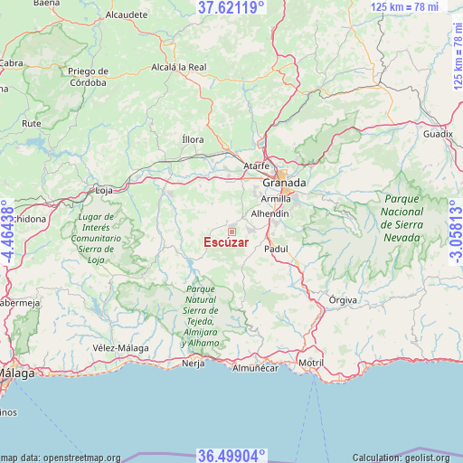
Escúzar GPS coordinates[2]
37° 3' 43.884" North, 3° 45' 40.536" West
| Map corner | latitude | longitude |
|---|---|---|
| Upper-left | 37.62119°, | -4.46438° |
| Center: | 37.06219°, | -3.76126° |
| Lower-right: | 36.49904°, | -3.05813° |
| Map W x H: | 124.8×124.8 km | = 77.5×77.5mi |
| max Lat: | 43.74134° ⇑94.9% North |
| Escúzar: | 37.06219° |
| min Lat: | ⇓5.1% South 27.64134° |
| min Long | Escúzar | max Long |
| -18.00367° | -3.76126° | 4.2899° |
| W 43.8%⇐ | ⇒56.2% E |
Elevation
Elevation of Escúzar is 874 m = 2867 ft, and this is 276 m = 906 ft above average elevation for this country.
| Max E: |
1682 m = 5518 ft | 22.6% |
| Escúzar | 874 m 2867 ft | |
| Avg. | 598 m = 1962 ft | |
Min E: |
0 m = 0 ft | 77.4% |
See also: Spain elevation on elevation.city.
Geographical zone
Escúzar is located in North temperate zone (between Tropic of Cancer and the Arctic Circle). Distance of this Northern Tropic circle is 1515 km =941.4 mi to South.| Distance of | km | miles | from Escúzar |
|---|---|---|---|
| North Pole | 5886.1 | 3657.5 | to North |
| Arctic Circle | 3280.2 | 2038.2 | to North |
| Tropic Cancer | 1515 | 941.4 | to South |
| Equator | 4120.9 | 2560.6 | to South |


Nearby cities:
15 places around Escúzar: (largest is in red/bold)
• Agrón
7 km =4.3 mi,  239°
239°
• Alhendín
11.5 km =7.1 mi,  63°
63°
• Armilla
15.1 km =9.4 mi,  53°
53°
• Chimeneas
9.3 km =5.8 mi,  325°
325°
• Churriana de la Vega
13.7 km =8.5 mi, 47°
• Cúllar-Vega
13 km =8.1 mi,  38°
38°
• Dílar
14.2 km =8.8 mi,  85°
85°
• Gójar
14.6 km =9.1 mi,  71°
71°
• Jayena
13.7 km =8.5 mi,  203°
203°
• Las Gabias
11.5 km =7.1 mi, 44°
• Ogíjares
15 km =9.3 mi, 65°
• Otura
11.7 km =7.3 mi,  75°
75°
• Padul
12.6 km =7.8 mi,  109°
109°
• Santafé
14.5 km =9 mi,  14°
14°
• Ventas de Huelma
5.2 km =3.2 mi,  277°
277°
Sources, notices
• [Note1] Compared only with cities in Spain existing in our database
• [Src1] Map data: © OpenStreetMap contributors (CC-BY-SA)
• [Src2] Other city data from geonames.org with taken over terms of usage.
• [Src3] Geographical zone / Annual Mean Temperature by Robert A. Rohde @ Wikipedia
