Santomera geodata
Santomera (Murcia) is a seat of a third-order administrative division; located in Spain in Europe/Madrid (GMT+2) time zone. With population of 15,319 people, there are 609 cities with bigger population in this country. Compared to other cities in Spain, 88.1% of cities are located further ↑North; 76.8% of cities are located further ←West and 93.1% of cities have higher elevation than Santomera. Note1


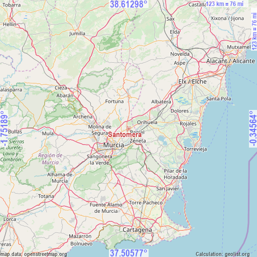
Santomera GPS coordinates[2]
38° 3' 41.292" North, 1° 2' 55.572" West
| Map corner | latitude | longitude |
|---|---|---|
| Upper-left | 38.61298°, | -1.75189° |
| Center: | 38.06147°, | -1.04877° |
| Lower-right: | 37.50577°, | -0.34564° |
| Map W x H: | 123.1×123.1 km | = 76.5×76.5mi |
| max Lat: | 43.74134° ⇑88.1% North |
| Santomera: | 38.06147° |
| min Lat: | ⇓11.9% South 27.64134° |
| min Long | Santomera | max Long |
| -18.00367° | -1.04877° | 4.2899° |
| W 76.8%⇐ | ⇒23.2% E |
Elevation
Elevation of Santomera is 38 m = 125 ft, and this is 560 m = 1837 ft below average elevation for this country.
| Max E: |
1682 m = 5518 ft | 93.1% |
| Avg. | 598 m = 1962 ft | |
| Santomera | 38 m = 125 ft | |
Min E: |
0 m = 0 ft | 6.9% |
See also: Spain elevation on elevation.city.
Geographical zone
Santomera is located in North temperate zone (between Tropic of Cancer and the Arctic Circle). Distance of this Northern Tropic circle is 1626.1 km =1010.4 mi to South.| Distance of | km | miles | from Santomera |
|---|---|---|---|
| North Pole | 5775 | 3588.4 | to North |
| Arctic Circle | 3169.1 | 1969.2 | to North |
| Tropic Cancer | 1626.1 | 1010.4 | to South |
| Equator | 4232 | 2629.6 | to South |


Nearby cities:
15 places around Santomera: (largest is in red/bold)
• Abanilla
16 km =9.9 mi,  2°
2°
• Barrio de San José Obrero
3.7 km =2.3 mi,  180°
180°
• Benferri
11.7 km =7.3 mi,  40°
40°
• Beniel
4.4 km =2.7 mi,  112°
112°
• Bigastro
13.2 km =8.2 mi,  89°
89°
• Cabecicos
6 km =3.7 mi,  208°
208°
• Cobatillas
2.5 km =1.6 mi,  254°
254°
• Esparragal
4.4 km =2.7 mi,  224°
224°
• Fortuna
14.9 km =9.3 mi,  333°
333°
• Jacarilla
15.8 km =9.8 mi, 89°
• Molina de Segura
13.9 km =8.6 mi,  266°
266°
• Murcia
10.9 km =6.8 mi, 220°
• Orihuela
9.5 km =5.9 mi,  74°
74°
• Redován
13.6 km =8.5 mi,  63°
63°
• Santa Cruz
4.5 km =2.8 mi,  189°
189°
Sources, notices
• [Note1] Compared only with cities in Spain existing in our database
• [Src1] Map data: © OpenStreetMap contributors (CC-BY-SA)
• [Src2] Other city data from geonames.org with taken over terms of usage.
• [Src3] Geographical zone / Annual Mean Temperature by Robert A. Rohde @ Wikipedia
