Beniel geodata
Beniel (Murcia) is a populated place; located in Spain in Europe/Madrid (GMT+2) time zone. With population of 10,933 people, there are 806 cities with bigger population in this country. Compared to other cities in Spain, 88.2% of cities are located further ↑North; 77.2% of cities are located further ←West and 93.9% of cities have higher elevation than Beniel. Note1


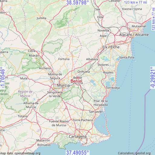
Beniel GPS coordinates[2]
38° 2' 46.896" North, 1° 0' 8.388" West
| Map corner | latitude | longitude |
|---|---|---|
| Upper-left | 38.59798°, | -1.70546° |
| Center: | 38.04636°, | -1.00233° |
| Lower-right: | 37.49055°, | -0.29921° |
| Map W x H: | 123.1×123.1 km | = 76.5×76.5mi |
| max Lat: | 43.74134° ⇑88.2% North |
| Beniel: | 38.04636° |
| min Lat: | ⇓11.8% South 27.64134° |
| min Long | Beniel | max Long |
| -18.00367° | -1.00233° | 4.2899° |
| W 77.2%⇐ | ⇒22.8% E |
Elevation
Elevation of Beniel is 32 m = 105 ft, and this is 566 m = 1857 ft below average elevation for this country.
| Max E: |
1682 m = 5518 ft | 93.9% |
| Avg. | 598 m = 1962 ft | |
| Beniel | 32 m = 105 ft | |
Min E: |
0 m = 0 ft | 6.1% |
See also: Spain elevation on elevation.city.
Geographical zone
Beniel is located in North temperate zone (between Tropic of Cancer and the Arctic Circle). Distance of this Northern Tropic circle is 1624.4 km =1009.4 mi to South.| Distance of | km | miles | from Beniel |
|---|---|---|---|
| North Pole | 5776.7 | 3589.5 | to North |
| Arctic Circle | 3170.8 | 1970.2 | to North |
| Tropic Cancer | 1624.4 | 1009.4 | to South |
| Equator | 4230.4 | 2628.6 | to South |


Nearby cities:
15 places around Beniel: (largest is in red/bold)
• Barrio de San José Obrero
4.6 km =2.9 mi,  243°
243°
• Benejúzar
14.7 km =9.1 mi,  76°
76°
• Benferri
11.1 km =6.9 mi,  18°
18°
• Bigastro
9.3 km =5.8 mi, 78°
• Cabecicos
7.8 km =4.8 mi, 242°
• Callosa de Segura
13.9 km =8.6 mi,  51°
51°
• Cobatillas
6.6 km =4.1 mi,  278°
278°
• Cox
14.6 km =9.1 mi,  43°
43°
• Esparragal
7.2 km =4.5 mi,  258°
258°
• Jacarilla
11.9 km =7.4 mi, 81°
• Murcia
13 km =8.1 mi, 239°
• Orihuela
6.7 km =4.2 mi, 50°
• Redován
11.2 km =7 mi, 46°
• Santa Cruz
5.5 km =3.4 mi, 240°
• Santomera
4.4 km =2.7 mi,  292°
292°
Sources, notices
• [Note1] Compared only with cities in Spain existing in our database
• [Src1] Map data: © OpenStreetMap contributors (CC-BY-SA)
• [Src2] Other city data from geonames.org with taken over terms of usage.
• [Src3] Geographical zone / Annual Mean Temperature by Robert A. Rohde @ Wikipedia
