Zahara geodata
Zahara (Andalusia) is a seat of a third-order administrative division; located in Spain in Europe/Madrid (GMT+2) time zone. With population of 1,571 people, there are 2408 cities with bigger population in this country. Compared to other cities in Spain, 96.5% of cities are located further ↑North; 77.3% of cities are located further →East and 62.6% of cities have higher elevation than Zahara. Note1


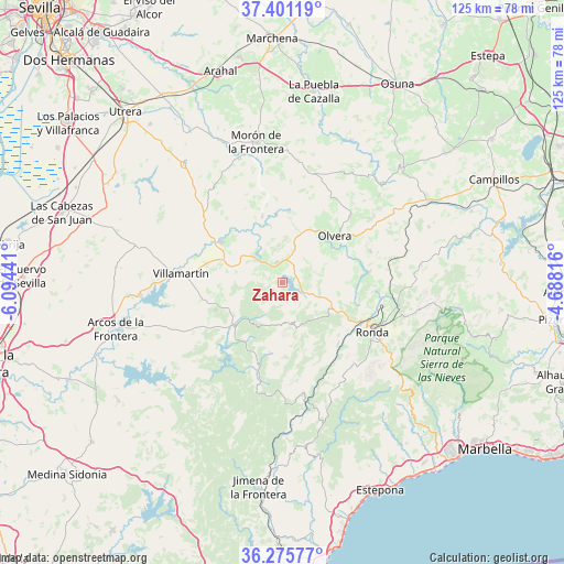
Zahara GPS coordinates[2]
36° 50' 25.98" North, 5° 23' 28.608" West
| Map corner | latitude | longitude |
|---|---|---|
| Upper-left | 37.40119°, | -6.09441° |
| Center: | 36.84055°, | -5.39128° |
| Lower-right: | 36.27577°, | -4.68816° |
| Map W x H: | 125.1×125.1 km | = 77.7×77.7mi |
| max Lat: | 43.74134° ⇑96.5% North |
| Zahara: | 36.84055° |
| min Lat: | ⇓3.5% South 27.64134° |
| min Long | Zahara | max Long |
| -18.00367° | -5.39128° | 4.2899° |
| W 22.7%⇐ | ⇒77.3% E |
Elevation
Elevation of Zahara is 491 m = 1611 ft, and this is 107 m = 351 ft below average elevation for this country.
| Max E: |
1682 m = 5518 ft | 62.6% |
| Avg. | 598 m = 1962 ft | |
| Zahara | 491 m = 1611 ft | |
Min E: |
0 m = 0 ft | 37.4% |
See also: Spain elevation on elevation.city.
Geographical zone
Zahara is located in North temperate zone (between Tropic of Cancer and the Arctic Circle). Distance of this Northern Tropic circle is 1490.4 km =926.1 mi to South.| Distance of | km | miles | from Zahara |
|---|---|---|---|
| North Pole | 5910.8 | 3672.8 | to North |
| Arctic Circle | 3304.9 | 2053.6 | to North |
| Tropic Cancer | 1490.4 | 926.1 | to South |
| Equator | 4096.3 | 2545.3 | to South |


Nearby cities:
15 places around Zahara: (largest is in red/bold)
• Algodonales
4.6 km =2.9 mi,  344°
344°
• Benaocaz
15.8 km =9.8 mi,  190°
190°
• Benaoján
18.3 km =11.4 mi,  137°
137°
• Coripe
15.4 km =9.6 mi, 343°
• El Bosque
13.7 km =8.5 mi,  227°
227°
• El Gastor
6.2 km =3.9 mi,  75°
75°
• Grazalema
9.2 km =5.7 mi,  167°
167°
• Montecorto
8.7 km =5.4 mi,  108°
108°
• Montejaque
17.1 km =10.6 mi,  132°
132°
• Olvera
15.2 km =9.4 mi,  46°
46°
• Prado del Rey
15.8 km =9.8 mi,  248°
248°
• Puerto Serrano
16.3 km =10.1 mi,  303°
303°
• Torre Alháquime
16.3 km =10.1 mi,  59°
59°
• Ubrique
18.7 km =11.6 mi,  195°
195°
• Villaluenga del Rosario
16 km =9.9 mi,  178°
178°
Sources, notices
• [Note1] Compared only with cities in Spain existing in our database
• [Src1] Map data: © OpenStreetMap contributors (CC-BY-SA)
• [Src2] Other city data from geonames.org with taken over terms of usage.
• [Src3] Geographical zone / Annual Mean Temperature by Robert A. Rohde @ Wikipedia
