Luque geodata
Luque (Andalusia) is a populated place; located in Spain in Europe/Madrid (GMT+2) time zone. With population of 3,253 people, there are 1645 cities with bigger population in this country. Compared to other cities in Spain, 91% of cities are located further ↑North; 63.6% of cities are located further →East and 52% of cities have lower elevation than Luque. Note1
Administrative division(s):
- Level 1: Andalusia
- Level 2: Province of Córdoba
- Level 3: Priego de Córdoba


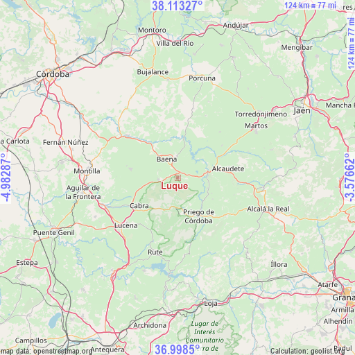
Luque GPS coordinates[2]
37° 33' 28.692" North, 4° 16' 47.064" West
| Map corner | latitude | longitude |
|---|---|---|
| Upper-left | 38.11327°, | -4.98287° |
| Center: | 37.55797°, | -4.27974° |
| Lower-right: | 36.9985°, | -3.57662° |
| Map W x H: | 124×124 km | = 77.1×77.1mi |
| max Lat: | 43.74134° ⇑91% North |
| Luque: | 37.55797° |
| min Lat: | ⇓9% South 27.64134° |
| min Long | Luque | max Long |
| -18.00367° | -4.27974° | 4.2899° |
| W 36.4%⇐ | ⇒63.6% E |
Elevation
Elevation of Luque is 679 m = 2228 ft, and this is 81 m = 266 ft above average elevation for this country.
| Max E: |
1682 m = 5518 ft | 48% |
| Luque | 679 m 2228 ft | |
| Avg. | 598 m = 1962 ft | |
Min E: |
0 m = 0 ft | 52% |
See also: Spain elevation on elevation.city.
Geographical zone
Luque is located in North temperate zone (between Tropic of Cancer and the Arctic Circle). Distance of this Northern Tropic circle is 1570.1 km =975.6 mi to South.| Distance of | km | miles | from Luque |
|---|---|---|---|
| North Pole | 5831 | 3623.2 | to North |
| Arctic Circle | 3225.1 | 2004 | to North |
| Tropic Cancer | 1570.1 | 975.6 | to South |
| Equator | 4176.1 | 2594.9 | to South |


Nearby cities:
15 places around Luque: (largest is in red/bold)
• Alcaudete
17.8 km =11.1 mi,  78°
78°
• Almedinilla
21.3 km =13.2 mi,  128°
128°
• Baena
7.5 km =4.7 mi,  330°
330°
• Cabra
17.2 km =10.7 mi,  236°
236°
• Carcabuey
12.7 km =7.9 mi,  177°
177°
• Castro del Río
23.1 km =14.4 mi,  309°
309°
• Doña Mencía
6.7 km =4.2 mi,  265°
265°
• Fuente-Tójar
12.9 km =8 mi,  113°
113°
• Lucena
24.6 km =15.3 mi,  227°
227°
• Nueva-Carteya
16.9 km =10.5 mi,  280°
280°
• Priego de Córdoba
15.3 km =9.5 mi,  150°
150°
• Rute
26.9 km =16.7 mi,  196°
196°
• Santiago de Calatrava
23.8 km =14.8 mi,  23°
23°
• Valenzuela
24.8 km =15.4 mi,  12°
12°
• Zuheros
3.5 km =2.2 mi, 242°
Sources, notices
• [Note1] Compared only with cities in Spain existing in our database
• [Src1] Map data: © OpenStreetMap contributors (CC-BY-SA)
• [Src2] Other city data from geonames.org with taken over terms of usage.
• [Src3] Geographical zone / Annual Mean Temperature by Robert A. Rohde @ Wikipedia
