Moratalla geodata
Moratalla (Murcia) is a seat of a third-order administrative division; located in Spain in Europe/Madrid (GMT+2) time zone. With population of 8,530 people, there are 910 cities with bigger population in this country. Compared to other cities in Spain, 87.2% of cities are located further ↑North; 68.6% of cities are located further ←West and 51.7% of cities have higher elevation than Moratalla. Note1


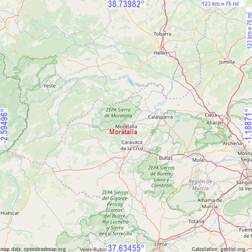
Moratalla GPS coordinates[2]
38° 11' 21.408" North, 1° 53' 30.588" West
| Map corner | latitude | longitude |
|---|---|---|
| Upper-left | 38.73982°, | -2.59496° |
| Center: | 38.18928°, | -1.89183° |
| Lower-right: | 37.63455°, | -1.18871° |
| Map W x H: | 122.9×122.9 km | = 76.4×76.4mi |
| max Lat: | 43.74134° ⇑87.2% North |
| Moratalla: | 38.18928° |
| min Lat: | ⇓12.8% South 27.64134° |
| min Long | Moratalla | max Long |
| -18.00367° | -1.89183° | 4.2899° |
| W 68.6%⇐ | ⇒31.4% E |
Elevation
Elevation of Moratalla is 641 m = 2103 ft, and this is 43 m = 141 ft above average elevation for this country.
| Max E: |
1682 m = 5518 ft | 51.7% |
| Moratalla | 641 m 2103 ft | |
| Avg. | 598 m = 1962 ft | |
Min E: |
0 m = 0 ft | 48.3% |
See also: Spain elevation on elevation.city.
Geographical zone
Moratalla is located in North temperate zone (between Tropic of Cancer and the Arctic Circle). Distance of this Northern Tropic circle is 1640.3 km =1019.2 mi to South.| Distance of | km | miles | from Moratalla |
|---|---|---|---|
| North Pole | 5760.8 | 3579.6 | to North |
| Arctic Circle | 3154.9 | 1960.4 | to North |
| Tropic Cancer | 1640.3 | 1019.2 | to South |
| Equator | 4246.2 | 2638.5 | to South |


Nearby cities:
15 places around Moratalla: (largest is in red/bold)
• Bullas
24.9 km =15.5 mi,  129°
129°
• Calasparra
17.4 km =10.8 mi,  74°
74°
• Caravaca
9.6 km =6 mi,  165°
165°
• Cehegín
13.5 km =8.4 mi,  142°
142°
• Cieza
41.6 km =25.8 mi,  82°
82°
• Elche de la Sierra
32.1 km =19.9 mi,  334°
334°
• Férez
20.2 km =12.6 mi, 332°
• Hellín
39.4 km =24.5 mi,  24°
24°
• Letur
26.9 km =16.7 mi,  317°
317°
• Liétor
39.7 km =24.7 mi,  352°
352°
• Mula
38.8 km =24.1 mi,  115°
115°
• Nerpio
36.2 km =22.5 mi,  262°
262°
• Pliego
40.5 km =25.2 mi, 123°
• Socovos
17.9 km =11.1 mi, 332°
• Yeste
42.2 km =26.2 mi,  298°
298°
Sources, notices
• [Note1] Compared only with cities in Spain existing in our database
• [Src1] Map data: © OpenStreetMap contributors (CC-BY-SA)
• [Src2] Other city data from geonames.org with taken over terms of usage.
• [Src3] Geographical zone / Annual Mean Temperature by Robert A. Rohde @ Wikipedia
