Hellín geodata
Hellín (Castille-La Mancha) is a seat of a third-order administrative division; located in Spain in Europe/Madrid (GMT+2) time zone. With population of 30,976 people, there are 293 cities with bigger population in this country. Compared to other cities in Spain, 85.6% of cities are located further ↑North; 70.6% of cities are located further ←West and 57.5% of cities have higher elevation than Hellín. Note1
Administrative division(s):
- Level 1: Castille-La Mancha
- Level 2: Provincia de Albacete
- Level 3: Hellín


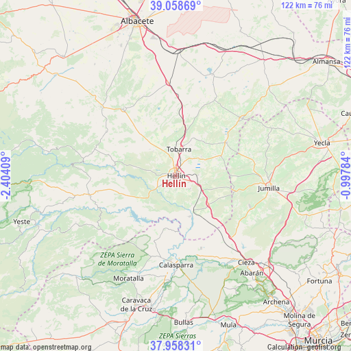
Hellín GPS coordinates[2]
38° 30' 38.16" North, 1° 42' 3.456" West
| Map corner | latitude | longitude |
|---|---|---|
| Upper-left | 39.05869°, | -2.40409° |
| Center: | 38.5106°, | -1.70096° |
| Lower-right: | 37.95831°, | -0.99784° |
| Map W x H: | 122.4×122.3 km | = 76.1×76mi |
| max Lat: | 43.74134° ⇑85.6% North |
| Hellín: | 38.5106° |
| min Lat: | ⇓14.4% South 27.64134° |
| min Long | Hellín | max Long |
| -18.00367° | -1.70096° | 4.2899° |
| W 70.6%⇐ | ⇒29.4% E |
Elevation
Elevation of Hellín is 557 m = 1827 ft, and this is 41 m = 135 ft below average elevation for this country.
| Max E: |
1682 m = 5518 ft | 57.5% |
| Avg. | 598 m = 1962 ft | |
| Hellín | 557 m = 1827 ft | |
Min E: |
0 m = 0 ft | 42.5% |
See also: Spain elevation on elevation.city.
Geographical zone
Hellín is located in North temperate zone (between Tropic of Cancer and the Arctic Circle). Distance of this Northern Tropic circle is 1676.1 km =1041.5 mi to South.| Distance of | km | miles | from Hellín |
|---|---|---|---|
| North Pole | 5725.1 | 3557.4 | to North |
| Arctic Circle | 3119.2 | 1938.2 | to North |
| Tropic Cancer | 1676.1 | 1041.5 | to South |
| Equator | 4282 | 2660.7 | to South |


Nearby cities:
15 places around Hellín: (largest is in red/bold)
• Albatana
16.9 km =10.5 mi,  66°
66°
• Alcadozo
28.7 km =17.8 mi,  302°
302°
• Ayna
33.5 km =20.8 mi,  277°
277°
• Calasparra
31.2 km =19.4 mi,  179°
179°
• Elche de la Sierra
30.9 km =19.2 mi,  257°
257°
• Fuente-Álamo
31 km =19.3 mi,  49°
49°
• Férez
31.6 km =19.6 mi,  235°
235°
• Jumilla
32.9 km =20.4 mi,  96°
96°
• Liétor
22.3 km =13.9 mi, 279°
• Ontur
21.2 km =13.2 mi,  56°
56°
• Peñas de San Pedro
35.9 km =22.3 mi,  312°
312°
• Pozo-Cañada
32.7 km =20.3 mi,  354°
354°
• Pozohondo
29.7 km =18.5 mi,  321°
321°
• Socovos
31.7 km =19.7 mi,  231°
231°
• Tobarra
9.1 km =5.7 mi,  4°
4°
Sources, notices
• [Note1] Compared only with cities in Spain existing in our database
• [Src1] Map data: © OpenStreetMap contributors (CC-BY-SA)
• [Src2] Other city data from geonames.org with taken over terms of usage.
• [Src3] Geographical zone / Annual Mean Temperature by Robert A. Rohde @ Wikipedia
