Calasparra geodata
Calasparra (Murcia) is a seat of a third-order administrative division; located in Spain in Europe/Madrid (GMT+2) time zone. With population of 10,759 people, there are 813 cities with bigger population in this country. Compared to other cities in Spain, 87.1% of cities are located further ↑North; 70.7% of cities are located further ←West and 71.6% of cities have higher elevation than Calasparra. Note1


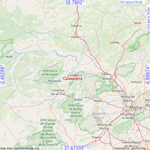
Calasparra GPS coordinates[2]
38° 13' 47.892" North, 1° 41' 59.496" West
| Map corner | latitude | longitude |
|---|---|---|
| Upper-left | 38.7802°, | -2.40299° |
| Center: | 38.22997°, | -1.69986° |
| Lower-right: | 37.67555°, | -0.99674° |
| Map W x H: | 122.8×122.8 km | = 76.3×76.3mi |
| max Lat: | 43.74134° ⇑87.1% North |
| Calasparra: | 38.22997° |
| min Lat: | ⇓12.9% South 27.64134° |
| min Long | Calasparra | max Long |
| -18.00367° | -1.69986° | 4.2899° |
| W 70.7%⇐ | ⇒29.3% E |
Elevation
Elevation of Calasparra is 355 m = 1165 ft, and this is 243 m = 797 ft below average elevation for this country.
| Max E: |
1682 m = 5518 ft | 71.6% |
| Avg. | 598 m = 1962 ft | |
| Calasparra | 355 m = 1165 ft | |
Min E: |
0 m = 0 ft | 28.4% |
See also: Spain elevation on elevation.city.
Geographical zone
Calasparra is located in North temperate zone (between Tropic of Cancer and the Arctic Circle). Distance of this Northern Tropic circle is 1644.9 km =1022.1 mi to South.| Distance of | km | miles | from Calasparra |
|---|---|---|---|
| North Pole | 5756.3 | 3576.8 | to North |
| Arctic Circle | 3150.4 | 1957.6 | to North |
| Tropic Cancer | 1644.9 | 1022.1 | to South |
| Equator | 4250.8 | 2641.3 | to South |


Nearby cities:
15 places around Calasparra: (largest is in red/bold)
• Abarán
26.4 km =16.4 mi,  95°
95°
• Blanca
29 km =18 mi, 101°
• Bullas
20.5 km =12.7 mi,  173°
173°
• Caravaca
19.9 km =12.4 mi,  225°
225°
• Cehegín
17.6 km =10.9 mi,  209°
209°
• Cieza
24.5 km =15.2 mi,  87°
87°
• Férez
29.4 km =18.3 mi,  296°
296°
• Hellín
31.2 km =19.4 mi,  359°
359°
• Moratalla
17.4 km =10.8 mi,  254°
254°
• Mula
27.9 km =17.3 mi,  138°
138°
• Ojós
32.6 km =20.3 mi,  106°
106°
• Pliego
31.7 km =19.7 mi,  147°
147°
• Ricote
30.4 km =18.9 mi, 106°
• Socovos
27.4 km =17 mi,  294°
294°
• Ulea
33.8 km =21 mi, 107°
Sources, notices
• [Note1] Compared only with cities in Spain existing in our database
• [Src1] Map data: © OpenStreetMap contributors (CC-BY-SA)
• [Src2] Other city data from geonames.org with taken over terms of usage.
• [Src3] Geographical zone / Annual Mean Temperature by Robert A. Rohde @ Wikipedia
