Férez geodata
Férez (Castille-La Mancha) is a seat of a third-order administrative division; located in Spain in Europe/Madrid (GMT+2) time zone. With population of 804 people, there are 3199 cities with bigger population in this country. Compared to other cities in Spain, 86.5% of cities are located further ↑North; 67.5% of cities are located further ←West and 51.8% of cities have lower elevation than Férez. Note1
Administrative division(s):
- Level 1: Castille-La Mancha
- Level 2: Provincia de Albacete
- Level 3: Férez


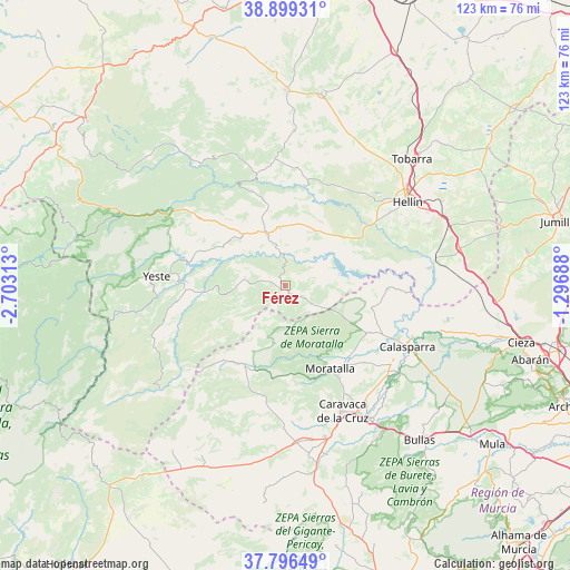
Férez GPS coordinates[2]
38° 21' 0" North, 2° 0' 0" West
| Map corner | latitude | longitude |
|---|---|---|
| Upper-left | 38.89931°, | -2.70313° |
| Center: | 38.35°, | -2° |
| Lower-right: | 37.79649°, | -1.29688° |
| Map W x H: | 122.6×122.6 km | = 76.2×76.2mi |
| max Lat: | 43.74134° ⇑86.5% North |
| Férez: | 38.35° |
| min Lat: | ⇓13.5% South 27.64134° |
| min Long | Férez | max Long |
| -18.00367° | -2° | 4.2899° |
| W 67.5%⇐ | ⇒32.5% E |
Elevation
Elevation of Férez is 677 m = 2221 ft, and this is 79 m = 259 ft above average elevation for this country.
| Max E: |
1682 m = 5518 ft | 48.2% |
| Férez | 677 m 2221 ft | |
| Avg. | 598 m = 1962 ft | |
Min E: |
0 m = 0 ft | 51.8% |
See also: Spain elevation on elevation.city.
Geographical zone
Férez is located in North temperate zone (between Tropic of Cancer and the Arctic Circle). Distance of this Northern Tropic circle is 1658.2 km =1030.4 mi to South.| Distance of | km | miles | from Férez |
|---|---|---|---|
| North Pole | 5742.9 | 3568.5 | to North |
| Arctic Circle | 3137.1 | 1949.3 | to North |
| Tropic Cancer | 1658.2 | 1030.4 | to South |
| Equator | 4264.1 | 2649.6 | to South |


Nearby cities:
15 places around Férez: (largest is in red/bold)
• Alcadozo
33.3 km =20.7 mi,  2°
2°
• Ayna
23.4 km =14.5 mi,  341°
341°
• Bogarra
31.7 km =19.7 mi,  324°
324°
• Calasparra
29.4 km =18.3 mi,  116°
116°
• Caravaca
29.7 km =18.5 mi,  156°
156°
• Cehegín
33.6 km =20.9 mi,  148°
148°
• Elche de la Sierra
12 km =7.5 mi, 339°
• Hellín
31.6 km =19.6 mi,  55°
55°
• Letur
9.1 km =5.7 mi,  281°
281°
• Liétor
21.8 km =13.5 mi,  10°
10°
• Molinicos
24.6 km =15.3 mi,  301°
301°
• Moratalla
20.2 km =12.6 mi, 152°
• Nerpio
34.7 km =21.6 mi,  229°
229°
• Socovos
2.4 km =1.5 mi, 146°
• Yeste
27.8 km =17.3 mi,  274°
274°
Sources, notices
• [Note1] Compared only with cities in Spain existing in our database
• [Src1] Map data: © OpenStreetMap contributors (CC-BY-SA)
• [Src2] Other city data from geonames.org with taken over terms of usage.
• [Src3] Geographical zone / Annual Mean Temperature by Robert A. Rohde @ Wikipedia
