Cehegín geodata
Cehegín (Murcia) is a populated place; located in Spain in Europe/Madrid (GMT+2) time zone. With population of 16,235 people, there are 582 cities with bigger population in this country. Compared to other cities in Spain, 87.9% of cities are located further ↑North; 69.5% of cities are located further ←West and 58.9% of cities have higher elevation than Cehegín. Note1


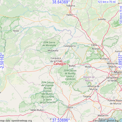
Cehegín GPS coordinates[2]
38° 5' 32.712" North, 1° 47' 54.6" West
| Map corner | latitude | longitude |
|---|---|---|
| Upper-left | 38.64369°, | -2.50162° |
| Center: | 38.09242°, | -1.7985° |
| Lower-right: | 37.53696°, | -1.09537° |
| Map W x H: | 123.1×123.1 km | = 76.5×76.5mi |
| max Lat: | 43.74134° ⇑87.9% North |
| Cehegín: | 38.09242° |
| min Lat: | ⇓12.1% South 27.64134° |
| min Long | Cehegín | max Long |
| -18.00367° | -1.7985° | 4.2899° |
| W 69.5%⇐ | ⇒30.5% E |
Elevation
Elevation of Cehegín is 541 m = 1775 ft, and this is 57 m = 187 ft below average elevation for this country.
| Max E: |
1682 m = 5518 ft | 58.9% |
| Avg. | 598 m = 1962 ft | |
| Cehegín | 541 m = 1775 ft | |
Min E: |
0 m = 0 ft | 41.1% |
See also: Spain elevation on elevation.city.
Geographical zone
Cehegín is located in North temperate zone (between Tropic of Cancer and the Arctic Circle). Distance of this Northern Tropic circle is 1629.6 km =1012.6 mi to South.| Distance of | km | miles | from Cehegín |
|---|---|---|---|
| North Pole | 5771.6 | 3586.3 | to North |
| Arctic Circle | 3165.7 | 1967.1 | to North |
| Tropic Cancer | 1629.6 | 1012.6 | to South |
| Equator | 4235.5 | 2631.8 | to South |


Nearby cities:
15 places around Cehegín: (largest is in red/bold)
• Abarán
37.1 km =23.1 mi,  70°
70°
• Albudeite
36.7 km =22.8 mi,  101°
101°
• Aledo
38.7 km =24 mi,  149°
149°
• Blanca
38.3 km =23.8 mi,  75°
75°
• Bullas
12.2 km =7.6 mi,  114°
114°
• Calasparra
17.6 km =10.9 mi,  29°
29°
• Campos del Río
39.4 km =24.5 mi, 98°
• Caravaca
5.9 km =3.7 mi,  284°
284°
• Cieza
36.9 km =22.9 mi,  63°
63°
• Férez
33.6 km =20.9 mi,  328°
328°
• Moratalla
13.5 km =8.4 mi,  322°
322°
• Mula
27.6 km =17.1 mi, 101°
• Pliego
28.2 km =17.5 mi, 113°
• Ricote
38.5 km =23.9 mi, 79°
• Socovos
31.3 km =19.4 mi, 328°
Sources, notices
• [Note1] Compared only with cities in Spain existing in our database
• [Src1] Map data: © OpenStreetMap contributors (CC-BY-SA)
• [Src2] Other city data from geonames.org with taken over terms of usage.
• [Src3] Geographical zone / Annual Mean Temperature by Robert A. Rohde @ Wikipedia
