Osuna geodata
Osuna (Andalusia) is a seat of a third-order administrative division; located in Spain in Europe/Madrid (GMT+2) time zone. With population of 17,851 people, there are 527 cities with bigger population in this country. Compared to other cities in Spain, 93.5% of cities are located further ↑North; 73.8% of cities are located further →East and 75.7% of cities have higher elevation than Osuna. Note1


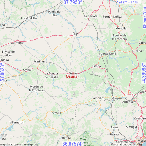
Osuna GPS coordinates[2]
37° 14' 15.36" North, 5° 6' 11.196" West
| Map corner | latitude | longitude |
|---|---|---|
| Upper-left | 37.7953°, | -5.80623° |
| Center: | 37.2376°, | -5.10311° |
| Lower-right: | 36.67574°, | -4.39998° |
| Map W x H: | 124.5×124.5 km | = 77.4×77.4mi |
| max Lat: | 43.74134° ⇑93.5% North |
| Osuna: | 37.2376° |
| min Lat: | ⇓6.5% South 27.64134° |
| min Long | Osuna | max Long |
| -18.00367° | -5.10311° | 4.2899° |
| W 26.2%⇐ | ⇒73.8% E |
Elevation
Elevation of Osuna is 289 m = 948 ft, and this is 309 m = 1014 ft below average elevation for this country.
| Max E: |
1682 m = 5518 ft | 75.7% |
| Avg. | 598 m = 1962 ft | |
| Osuna | 289 m = 948 ft | |
Min E: |
0 m = 0 ft | 24.3% |
See also: Spain elevation on elevation.city.
Geographical zone
Osuna is located in North temperate zone (between Tropic of Cancer and the Arctic Circle). Distance of this Northern Tropic circle is 1534.5 km =953.5 mi to South.| Distance of | km | miles | from Osuna |
|---|---|---|---|
| North Pole | 5866.6 | 3645.3 | to North |
| Arctic Circle | 3260.7 | 2026.1 | to North |
| Tropic Cancer | 1534.5 | 953.5 | to South |
| Equator | 4140.4 | 2572.7 | to South |


Nearby cities:
15 places around Osuna: (largest is in red/bold)
• Aguadulce
9.9 km =6.2 mi,  80°
80°
• Algámitas
25.1 km =15.6 mi,  189°
189°
• El Rubio
16.6 km =10.3 mi,  37°
37°
• El Saucejo
18.4 km =11.4 mi,  178°
178°
• Estepa
20.8 km =12.9 mi,  72°
72°
• Gilena
16.8 km =10.4 mi, 84°
• La Lantejuela
16.8 km =10.4 mi,  320°
320°
• La Puebla de Cazalla
18.5 km =11.5 mi,  264°
264°
• Lora de Estepa
24.6 km =15.3 mi, 81°
• Los Corrales
18.6 km =11.6 mi,  145°
145°
• Marinaleda
19.5 km =12.1 mi, 40°
• Martín de la Jara
18.9 km =11.7 mi,  139°
139°
• Pedrera
18.5 km =11.5 mi,  93°
93°
• Sierra de Yeguas
24.4 km =15.2 mi,  121°
121°
• Villanueva de San Juan
21.9 km =13.6 mi,  197°
197°
Sources, notices
• [Note1] Compared only with cities in Spain existing in our database
• [Src1] Map data: © OpenStreetMap contributors (CC-BY-SA)
• [Src2] Other city data from geonames.org with taken over terms of usage.
• [Src3] Geographical zone / Annual Mean Temperature by Robert A. Rohde @ Wikipedia
