La Puebla de Cazalla geodata
La Puebla de Cazalla (Andalusia) is a populated place; located in Spain in Europe/Madrid (GMT+2) time zone. With population of 11,325 people, there are 776 cities with bigger population in this country. Compared to other cities in Spain, 93.8% of cities are located further ↑North; 76.5% of cities are located further →East and 82.5% of cities have higher elevation than La Puebla de Cazalla. Note1
Administrative division(s):
- Level 1: Andalusia
- Level 2: Provincia de Sevilla
- Level 3: Morón de la Frontera


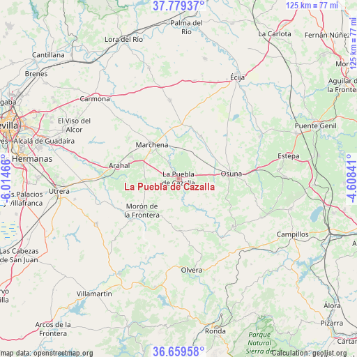
La Puebla de Cazalla GPS coordinates[2]
37° 13' 17.58" North, 5° 18' 41.508" West
| Map corner | latitude | longitude |
|---|---|---|
| Upper-left | 37.77937°, | -6.01466° |
| Center: | 37.22155°, | -5.31153° |
| Lower-right: | 36.65958°, | -4.60841° |
| Map W x H: | 124.5×124.5 km | = 77.4×77.4mi |
| max Lat: | 43.74134° ⇑93.8% North |
| La Puebla de Cazalla: | 37.22155° |
| min Lat: | ⇓6.2% South 27.64134° |
| min Long | La Puebla de Ca | max Long |
| -18.00367° | -5.31153° | 4.2899° |
| W 23.5%⇐ | ⇒76.5% E |
Elevation
Elevation of La Puebla de Cazalla is 177 m = 581 ft, and this is 421 m = 1381 ft below average elevation for this country.
| Max E: |
1682 m = 5518 ft | 82.5% |
| Avg. | 598 m = 1962 ft | |
| La Puebla de Cazalla | 177 m = 581 ft | |
Min E: |
0 m = 0 ft | 17.5% |
See also: Spain elevation on elevation.city.
Geographical zone
La Puebla de Cazalla is located in North temperate zone (between Tropic of Cancer and the Arctic Circle). Distance of this Northern Tropic circle is 1532.7 km =952.4 mi to South.| Distance of | km | miles | from La Puebla de Cazalla |
|---|---|---|---|
| North Pole | 5868.4 | 3646.5 | to North |
| Arctic Circle | 3262.5 | 2027.2 | to North |
| Tropic Cancer | 1532.7 | 952.4 | to South |
| Equator | 4138.6 | 2571.6 | to South |


Nearby cities:
15 places around La Puebla de Cazalla: (largest is in red/bold)
• Aguadulce
28.4 km =17.6 mi,  82°
82°
• Algámitas
27.1 km =16.8 mi,  147°
147°
• Coripe
29.9 km =18.6 mi,  202°
202°
• El Arahal
21.2 km =13.2 mi,  282°
282°
• El Rubio
32.2 km =20 mi,  62°
62°
• El Saucejo
25.2 km =15.7 mi,  131°
131°
• Fuentes de Andalucía
27.1 km =16.8 mi,  353°
353°
• La Lantejuela
16.6 km =10.3 mi,  27°
27°
• Los Corrales
32 km =19.9 mi,  115°
115°
• Marchena
15.1 km =9.4 mi,  322°
322°
• Morón de la Frontera
16.9 km =10.5 mi,  228°
228°
• Osuna
18.5 km =11.5 mi, 84°
• Paradas
18.1 km =11.2 mi,  295°
295°
• Pruna
28.8 km =17.9 mi,  164°
164°
• Villanueva de San Juan
22.6 km =14 mi, 147°
Sources, notices
• [Note1] Compared only with cities in Spain existing in our database
• [Src1] Map data: © OpenStreetMap contributors (CC-BY-SA)
• [Src2] Other city data from geonames.org with taken over terms of usage.
• [Src3] Geographical zone / Annual Mean Temperature by Robert A. Rohde @ Wikipedia
