Aguadulce geodata
Aguadulce (Andalusia) is a seat of a third-order administrative division; located in Spain in Europe/Madrid (GMT+2) time zone. With population of 1,989 people, there are 2177 cities with bigger population in this country. Compared to other cities in Spain, 93.4% of cities are located further ↑North; 72.4% of cities are located further →East and 77% of cities have higher elevation than Aguadulce. Note1


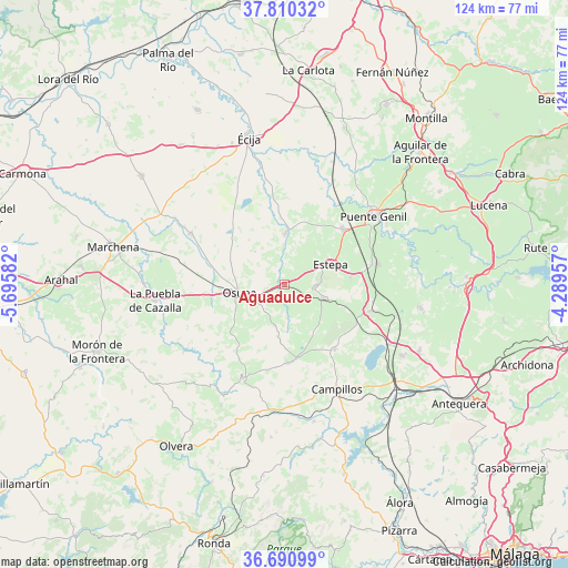
Aguadulce GPS coordinates[2]
37° 15' 9.828" North, 4° 59' 33.684" West
| Map corner | latitude | longitude |
|---|---|---|
| Upper-left | 37.81032°, | -5.69582° |
| Center: | 37.25273°, | -4.99269° |
| Lower-right: | 36.69099°, | -4.28957° |
| Map W x H: | 124.5×124.5 km | = 77.4×77.4mi |
| max Lat: | 43.74134° ⇑93.4% North |
| Aguadulce: | 37.25273° |
| min Lat: | ⇓6.6% South 27.64134° |
| min Long | Aguadulce | max Long |
| -18.00367° | -4.99269° | 4.2899° |
| W 27.6%⇐ | ⇒72.4% E |
Elevation
Elevation of Aguadulce is 269 m = 883 ft, and this is 329 m = 1079 ft below average elevation for this country.
| Max E: |
1682 m = 5518 ft | 77% |
| Avg. | 598 m = 1962 ft | |
| Aguadulce | 269 m = 883 ft | |
Min E: |
0 m = 0 ft | 23% |
See also: Spain elevation on elevation.city.
Geographical zone
Aguadulce is located in North temperate zone (between Tropic of Cancer and the Arctic Circle). Distance of this Northern Tropic circle is 1536.2 km =954.6 mi to South.| Distance of | km | miles | from Aguadulce |
|---|---|---|---|
| North Pole | 5864.9 | 3644.3 | to North |
| Arctic Circle | 3259.1 | 2025.1 | to North |
| Tropic Cancer | 1536.2 | 954.6 | to South |
| Equator | 4142.1 | 2573.8 | to South |


Nearby cities:
15 places around Aguadulce: (largest is in red/bold)
• Casariche
21.1 km =13.1 mi,  77°
77°
• El Rubio
11.5 km =7.1 mi,  1°
1°
• El Saucejo
22.1 km =13.7 mi,  204°
204°
• Estepa
11 km =6.8 mi,  66°
66°
• Gilena
6.9 km =4.3 mi,  91°
91°
• Herrera
17.7 km =11 mi,  45°
45°
• La Lantejuela
23.4 km =14.5 mi,  298°
298°
• La Roda de Andalucía
19.8 km =12.3 mi,  105°
105°
• Lora de Estepa
14.7 km =9.1 mi, 82°
• Los Corrales
17.1 km =10.6 mi,  177°
177°
• Marinaleda
13.5 km =8.4 mi,  12°
12°
• Martín de la Jara
16.2 km =10.1 mi,  170°
170°
• Osuna
9.9 km =6.2 mi,  260°
260°
• Pedrera
9.2 km =5.7 mi, 108°
• Sierra de Yeguas
18.1 km =11.2 mi,  142°
142°
Sources, notices
• [Note1] Compared only with cities in Spain existing in our database
• [Src1] Map data: © OpenStreetMap contributors (CC-BY-SA)
• [Src2] Other city data from geonames.org with taken over terms of usage.
• [Src3] Geographical zone / Annual Mean Temperature by Robert A. Rohde @ Wikipedia
